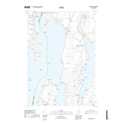
2019 Map of Rouses Point
USGS Topo · Published 2019About this map
Lake Champlain dominates this borderland landscape, where the international and state boundaries intersect near Rouses Point and the Alburg Tongue. This survey illustrates the intricate relationship between land and water in the Champlain Valley, highlighting the series of points and reefs such as Windmill Point and Point au Fer Reef that have long dictated navigation. On the Vermont side, the map details the rural character of Alburgh and the island community of Isle la Motte, which is connected by a network of local roads including Main St and Church St. Local heritage is preserved in numerous burial grounds like Bush Cem and the Reynolds McGregor Cem, while modern infrastructure is represented by the Rouses Point Bridge and the small Hawk's Nest Airport. The mapping of features like Stanhope Hill and Big Bluff provides a clear view of the localized topography that defines these lakeside settlements.
Find a feature on this map
108 named features on this map. Tap any name to fly to it.
Don’t see what you’re looking for? This feature index may not catch every label — zoom into the map to look around manually.
Map Details
Editions of this 2019 Rouses Point Map
This is the sole edition of this map. No revisions or reprints were ever made.
Other maps of this area

1895 · Rouse Point
USGS Topo · 1:62,500

1907 · Rouse Point
USGS Topo · 1:62,500

1914 · St. Albans
USGS Topo · 1:48,000

1916 · St. Albans
USGS Topo · 1:62,500

1939 · Rouses Point
USGS Topo · 1:62,500

1943 · Rouses Point
USGS Topo · 1:62,500

1943 · St. Albans
USGS Topo · 1:62,500

1950 · Lake Champlain
USGS Topo · 1:250,000

1956 · Rouses Point
USGS Topo · 1:62,500

1958 · Lake Champlain
USGS Topo · 1:250,000