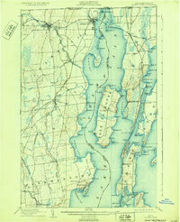
1907 Map of Rouses Point
USGS Topo · Published 1932About this map
Fort Montgomery stands at the northern boundary of this lakefront survey, overlooking the strategic narrows where Lake Champlain meets the Canadian border. The landscape is defined by the intricate shoreline of the lake, including the prominent island of Isle La Motte and the peninsula of Alburg. A robust early 20th-century transportation network is evident, with the Rutland R. R., Central Vermont R. R., and Delaware and Hudson R. R. converging near Rouses Point. The waterway itself remains a primary artery for commerce, noted by The Gut G.T. Co Steamers route passing between the islands. Along the western shore, small settlements like Chazy Landing and Point au Roche serve as local hubs, while numerous navigational aids such as the Isle La Motte L.H. and Point au Roche L.H. guide traffic through the bays and passages.
Find a feature on this map
108 named features on this map. Tap any name to fly to it.
Don’t see what you’re looking for? This feature index may not catch every label — zoom into the map to look around manually.
Map Details
Editions of this 1907 Rouses Point Map
5 editions found
Other maps of this area

1894 · Plattsburg
USGS Topo · 1:62,500

1895 · Mooers
USGS Topo · 1:62,500

1895 · Rouse Point
USGS Topo · 1:62,500

1899 · Mooers
USGS Topo · 1:62,500

1906 · Plattsburg
USGS Topo · 1:62,500

1907 · Rouse Point
USGS Topo · 1:62,500

1913 · Dannemora
USGS Topo · 1:62,500

1913 · Milton
USGS Topo · 1:48,000

1914 · St. Albans
USGS Topo · 1:48,000

1915 · Milton
USGS Topo · 1:62,500