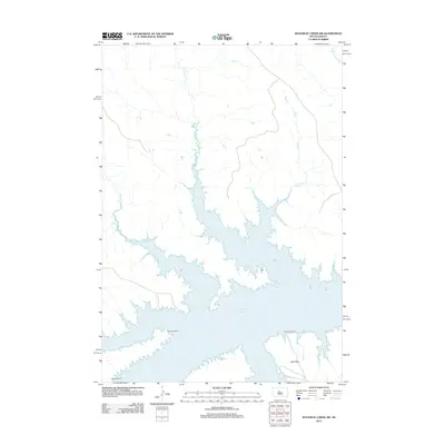
2012 Map of Rousseau Creek SW
USGS Topo · Published 2012About this map
Lake Oahe dominates the southern half of this landscape, its complex, finger-like shoreline reaching into the prairie drainages of Dewey County. The geography is defined by a series of named creek systems, including Fishgut Cr and Sage Cr, which flow south toward the reservoir. In this sparsely populated ranching country, human presence is marked by isolated holdings such as Holloway Ranch and Chisholm Ranch situated near the water's edge. To the southwest, High Elk Ranch sits near the higher ground of Little Flats. The map illustrates the contemporary relationship between the expansive Missouri River reservoir system and the traditional land use of the northern plains, where large-scale cattle ranching remains the primary activity across the vast sections of the open range.
Find a feature on this map
9 named features on this map. Tap any name to fly to it.
Don’t see what you’re looking for? This feature index may not catch every label — zoom into the map to look around manually.
Map Details
Editions of this 2012 Rousseau Creek SW Map
This is the sole edition of this map. No revisions or reprints were ever made.
Other maps of this area

1954 · Pierre
USGS Topo · 1:250,000

1956 · Rousseau Creek SW
USGS Topo · 1:24,000

1956 · Herbert Creek SE
USGS Topo · 1:24,000

1956 · Sansarc NE
USGS Topo · 1:24,000

1956 · Crockett Mountains
USGS Topo · 1:24,000

1958 · Pierre
USGS Topo · 1:250,000

1969 · Rousseau Creek
USGS Topo · 1:24,000

1981 · Charlie Creek
USGS Topo · 1:24,000

1981 · Rousseau Creek NW
USGS Topo · 1:24,000

1981 · Herbert Creek NE
USGS Topo · 1:24,000