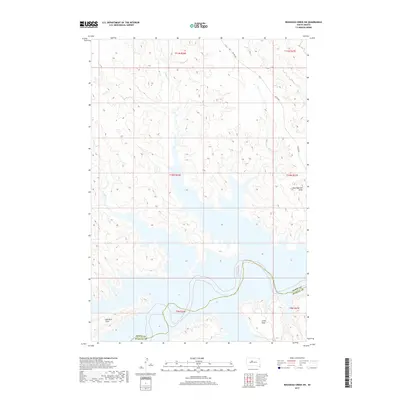
2017 Map of Rousseau Creek SW
USGS Topo · Published 2017About this map
Lake Oahe dominates the southern landscape of this 2017 survey, where its expansive waters meet the rugged breaks of the Missouri River valley. The terrain is defined by a network of seasonal drainages including Fishgut Cr, Sage Cr, and Paradis Cr, which carve through the high prairie plateaus. This remote section of South Dakota, spanning the boundary between Dewey and Stanley Counties, shows a landscape primarily shaped by topography rather than dense settlement. Large, flat uplands such as Kid Rich Flats and Little Flats provide a distinct contrast to the deeply etched coulees like Fine Weather Draw. Transportation is sparse, with Bia Rd 803 serving as one of the few named corridors providing access through the Missouri River breaks and across the section lines of the Cheyenne River Indian Reservation.
Find a feature on this map
15 named features on this map. Tap any name to fly to it.
Don’t see what you’re looking for? This feature index may not catch every label — zoom into the map to look around manually.
Map Details
Editions of this 2017 Rousseau Creek SW Map
This is the sole edition of this map. No revisions or reprints were ever made.
Other maps of this area

1954 · Pierre
USGS Topo · 1:250,000

1956 · Rousseau Creek SW
USGS Topo · 1:24,000

1956 · Herbert Creek SE
USGS Topo · 1:24,000

1956 · Sansarc NE
USGS Topo · 1:24,000

1956 · Crockett Mountains
USGS Topo · 1:24,000

1958 · Pierre
USGS Topo · 1:250,000

1969 · Rousseau Creek
USGS Topo · 1:24,000

1981 · Charlie Creek
USGS Topo · 1:24,000

1981 · Rousseau Creek NW
USGS Topo · 1:24,000

1981 · Herbert Creek NE
USGS Topo · 1:24,000