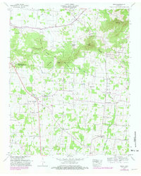
1949 Map of Rover
USGS Topo · Published 1981About this map
The Tennessee Valley Divide snakes across this landscape, separating the headwaters of Concord Creek from the drainage basins of Fruit Valley Creek and Alexander Creek. This 1949 survey, field-checked just after the war and later updated with 1979 aerial data, captures the rural character of the Rutherford and Bedford county line. The settlement of Rover serves as a local hub, surrounded by a dense network of family cemeteries and country churches that speak to generations of upland farming. Notable landmarks such as Puckett Store and Vernon Corner School highlight the civic focal points of these small communities. The terrain transitions from the low-lying Byler Bottoms to prominent rises like Versailles Knob and Pinnacle Hill, illustrating the varied topography of middle Tennessee's interior before modern expansion altered these rural corridors.
Find a feature on this map
84 named features on this map. Tap any name to fly to it.
Don’t see what you’re looking for? This feature index may not catch every label — zoom into the map to look around manually.
Map Details
Editions of this 1949 Rover Map
3 editions found
Other maps of this area

1916 · Murfreesboro
USGS Topo · 1:62,500

1936 · Chapel Hill
USGS Topo · 1:24,000

1936 · Farmington
USGS Topo · 1:24,000

1936 · Rover
USGS Topo · 1:24,000

1936 · Deason
USGS Topo · 1:24,000

1936 · Unionville
USGS Topo · 1:24,000

1936 · Fosterville
USGS Topo · 1:24,000

1942 · Lebanon
USGS Topo · 1:100,000

1944 · Shelbyville
USGS Topo · 1:100,000
1947 · Farmington
USGS Topo · 1:24,000