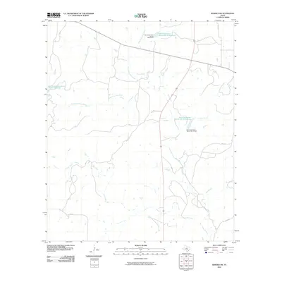
2010 Map of Rowden NW
USGS Topo · Published 2010About this map
Pecan Bayou and its numerous tributaries dominate this drainage-focused landscape in Callahan County. The hydrology is defined by mid-century land management infrastructure, most notably the Soil Conservation Service Site 12 Reservoir and the Soil Conservation Service Site 11a Reservoir. These man-made features, along with corresponding structures like the Soil Conservation Service Site 10 Dam, reflect an era of intensive soil and water conservation efforts meant to manage the flow of the North Prong Pecan Bayou and South Prong Pecan Bayou.
Find a feature on this map
15 named features on this map. Tap any name to fly to it.
Don’t see what you’re looking for? This feature index may not catch every label — zoom into the map to look around manually.
Map Details
Editions of this 2010 Rowden NW Map
This is the sole edition of this map. No revisions or reprints were ever made.
Other maps of this area

1890 · Abilene
USGS Topo · 1:125,000

1892 · Abilene
USGS Topo · 1:125,000

1931 · Baird
USGS Topo · 1:125,000

1932 · Baird
USGS Topo · 1:125,000

1954 · Abilene
USGS Topo · 1:250,000

1957 · Kirby Lake
USGS Topo · 1:62,500

1958 · Abilene
USGS Topo · 1:250,000
1960 · Webbville
USGS Topo · 1:24,000
1960 · Crooked Creek
USGS Topo · 1:24,000

1966 · Admiral
USGS Topo · 1:24,000