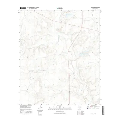
2016 Map of Rowden NW
USGS Topo · Published 2016About this map
The upper reaches of Pecan Bayou define this rural landscape in Callahan County, where the north, south, and main prongs of the waterway converge. The topography is marked by significant water management efforts, notably the Soil Conservation Service Site 10 Reservoir and Soil Conservation Service Site 12 Reservoir, which anchor the drainage system of this cattle-country terrain. Small seasonal tributaries like Condemn Br and Clear Cr meander through the draws, reflecting a land deeply tied to its hydrology. The human footprint is sparse, characterized by a network of ranch roads and county routes such as Co RD 479 and Fm 2926. This 2016 survey illustrates the modern configuration of traditional Texas ranchlands, where private drives like PVT RD 4106 provide access to the interior pastures and creek bottoms.
Find a feature on this map
18 named features on this map. Tap any name to fly to it.
Don’t see what you’re looking for? This feature index may not catch every label — zoom into the map to look around manually.
Map Details
Editions of this 2016 Rowden NW Map
This is the sole edition of this map. No revisions or reprints were ever made.
Other maps of this area

1890 · Abilene
USGS Topo · 1:125,000

1892 · Abilene
USGS Topo · 1:125,000

1931 · Baird
USGS Topo · 1:125,000

1932 · Baird
USGS Topo · 1:125,000

1954 · Abilene
USGS Topo · 1:250,000

1957 · Kirby Lake
USGS Topo · 1:62,500

1958 · Abilene
USGS Topo · 1:250,000
1960 · Webbville
USGS Topo · 1:24,000
1960 · Crooked Creek
USGS Topo · 1:24,000

1966 · Admiral
USGS Topo · 1:24,000