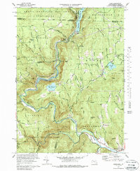
1973 Map of Rowe
USGS Topo · Published 1988About this map
Deerfield River hydro-electric infrastructure and the engineering feat of the Hoosac Tunnel define this portion of the northern Berkshires. By the early 1970s, the landscape around Rowe and Monroe had been heavily reshaped by the Sherman Reservoir and its associated powerplant, alongside the complex pump-storage systems of the Upper Reservoir Bear Swamp and Lower Reservoir. These industrial developments sit in stark contrast to the preserved landscapes of the Green Mountain National Forest and Monroe State Forest.
Find a feature on this map
65 named features on this map. Tap any name to fly to it.
Don’t see what you’re looking for? This feature index may not catch every label — zoom into the map to look around manually.
Map Details
Editions of this 1973 Rowe Map
4 editions found
Other maps of this area

1886 · Greylock
USGS Topo · 1:62,500

1886 · Hawley
USGS Topo · 1:62,500

1889 · Wilmington
USGS Topo · 1:62,500

1890 · Hawley
USGS Topo · 1:62,500

1891 · Wilmington
USGS Topo · 1:62,500

1891 · Greylock
USGS Topo · 1:62,500

1893 · Greylock
USGS Topo · 1:62,500

1894 · Hawley
USGS Topo · 1:62,500

1898 · Bennington
USGS Topo · 1:62,500

1898 · Greylock
USGS Topo · 1:62,500