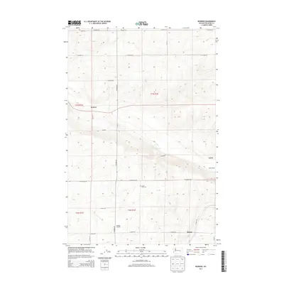
2013 Map of Roxboro
USGS Topo · Published 2013About this map
Kansas Prairie dominates this section of eastern Washington, where agricultural patterns are defined by a grid of rural roads and the natural contours of the land. Small rural settlements like Roxboro and Servia appear along the corridor north of the prominent Lind Coulee, while Beatrice is situated further south near the intersection of S Damon Rd and W Herman Rd. This 2013 survey illustrates the enduring rural character of the region, anchored by historical landmarks such as the Kansas Prairie Cem. The landscape is etched with the drainage patterns leading into the coulee, contrasting with the straight-line organization of the Public Land Survey System sections that divide the wheat-growing country. Local transit relies on a network of established routes including W Providence Rd and N Roxboro Rd, which connect these isolated points of interest across the plateau.
Find a feature on this map
24 named features on this map. Tap any name to fly to it.
Don’t see what you’re looking for? This feature index may not catch every label — zoom into the map to look around manually.
Map Details
Editions of this 2013 Roxboro Map
This is the sole edition of this map. No revisions or reprints were ever made.
Other maps of this area

1916 · Connell
USGS Topo · 1:125,000

1918 · Connell
USGS Topo · 1:125,000

1925 · Schrag
USGS Topo · 1:62,500

1953 · Walla Walla
USGS Topo · 1:250,000

1953 · Ritzville
USGS Topo · 1:250,000

1958 · Walla Walla
USGS Topo · 1:250,000

1959 · Ritzville
USGS Topo · 1:250,000

1965 · Ritzville
USGS Topo · 1:250,000

1967 · Reiman SW
USGS Topo · 1:24,000
1967 · Weber
USGS Topo · 1:24,000