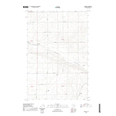
2020 Map of Roxboro
USGS Topo · Published 2020About this map
Kansas Prairie anchors this portion of Adams County, where the topography of the Columbia Plateau is defined by the sweeping lines of the Palouse To Cascades State Park Trail. This trail, following the path of a former rail corridor, cuts diagonally across the landscape, passing through the small settlements of Roxboro and Servia. The area’s agricultural and pioneer history is reflected in the presence of the Kansas Prairie Cem located along Providence Rd. This survey shows a systematic grid of section lines and gravel roads, such as N Roxboro Rd and W Herman Rd, which provide access to the vast dryland farming operations characteristic of this region. To the south, the community of Beatrice sits near the junction of S Damon Rd, illustrating the dispersed nature of rural development in this part of Washington.
Find a feature on this map
31 named features on this map. Tap any name to fly to it.
Don’t see what you’re looking for? This feature index may not catch every label — zoom into the map to look around manually.
Map Details
Editions of this 2020 Roxboro Map
This is the sole edition of this map. No revisions or reprints were ever made.
Other maps of this area

1916 · Connell
USGS Topo · 1:125,000

1918 · Connell
USGS Topo · 1:125,000

1925 · Schrag
USGS Topo · 1:62,500

1953 · Walla Walla
USGS Topo · 1:250,000

1953 · Ritzville
USGS Topo · 1:250,000

1958 · Walla Walla
USGS Topo · 1:250,000

1959 · Ritzville
USGS Topo · 1:250,000

1965 · Ritzville
USGS Topo · 1:250,000

1967 · Reiman SW
USGS Topo · 1:24,000
1967 · Weber
USGS Topo · 1:24,000