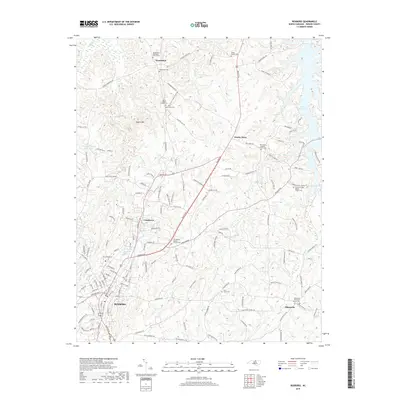
2019 Map of Roxboro
USGS Topo · Published 2019About this map
Roxboro serves as the focal point of this Person County landscape, where the urban grid of the county seat meets a rural network of churches and family cemeteries. To the north, the terrain is defined by Hagers Mtn and the winding course of Marlowe Cr, which feeds into the larger Mayo Reservoir system at the eastern boundary. The map documents a dense concentration of religious and genealogical sites, ranging from the Woodsdale Methodist Church Cem in the north to Allensville in the southeast. Smaller hamlets like Longhurst and Gentry Store appear alongside specialized landmarks such as the Roxboro Country Club. This topography illustrates the persistent rural character of the North Carolina Piedmont, where modern roadways like Boston Rd and Halifax Rd connect long-standing community centers and family burial grounds like the Allen Family Cem.
Find a feature on this map
147 named features on this map. Tap any name to fly to it.
Don’t see what you’re looking for? This feature index may not catch every label — zoom into the map to look around manually.
Map Details
Editions of this 2019 Roxboro Map
This is the sole edition of this map. No revisions or reprints were ever made.
Other maps of this area

1943 · Roxboro
USGS Topo · 1:62,500

1952 · Milton
USGS Topo · 1:62,500

1953 · South Boston
USGS Topo · 1:62,500

1953 · Greensboro
USGS Topo · 1:250,000

1954 · Greensboro
USGS Topo · 1:250,000

1956 · Milton
USGS Topo · 1:62,500

1957 · South Boston
USGS Topo · 1:62,500

1962 · Greensboro
USGS Topo · 1:250,000

1966 · Greensboro
USGS Topo · 1:250,000

1968 · Hurdle Mills
USGS Topo · 1:24,000