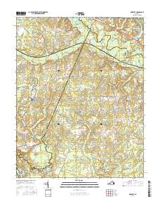
2016 Map of Roxbury
USGS Topo · Published 2016About this map
Malvern Hill and the surrounding coastal plain of Charles City County are preserved here in a modern survey that emphasizes the complex hydrography of the Virginia Tidewater. The landscape is defined by extensive wetlands, including White Oak Swamp, Canal Swamp, and Toe Ink Swamp, which feed into the meandering Chickahominy River. These water systems historically dictated the placement of early settlements and road networks, visible in the positioning of Ednas Mill and Roxbury.
Find a feature on this map
101 named features on this map. Tap any name to fly to it.
Don’t see what you’re looking for? This feature index may not catch every label — zoom into the map to look around manually.
Map Details
Editions of this 2016 Roxbury Map
This is the sole edition of this map. No revisions or reprints were ever made.
Other maps of this area

1894 · Bermuda Hundred
USGS Topo · 1:62,500

1894 · Richmond
USGS Topo · 1:62,500

1895 · Richmond
USGS Topo · 1:62,500

1918 · Charles City
USGS Topo · 1:62,500

1920 · King William
USGS Topo · 1:62,500

1934 · Seven Pines
USGS Topo · 1:24,000

1938 · Dutch Gap
USGS Topo · 1:24,000

1938 · Seven Pines
USGS Topo · 1:31,680

1943 · Dutch Gap
USGS Topo · 1:31,680

1943 · Hopewell
USGS Topo · 1:31,680