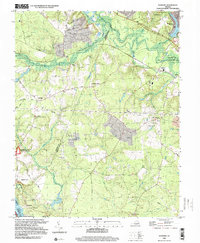
1999 Map of Roxbury
USGS Topo · Published 2000About this map
Glendale National Cemetery and parts of the Richmond National Battlefield Park anchor this landscape, marking the site of significant Civil War engagements. The terrain transitions from the low-lying wetlands of the Chickahominy River and White Oak Swamp Creek in the north to the higher ground of Malvern Hill overlooking the James River and Presquile National Wildlife Refuge to the south. Small rural crossroads and family settlements like Hughes Store, Nances Shop, and Elko are linked by a network of historic routes including Charles City Road and Darbytown Road. Local industry and agriculture are represented by features such as Ednas Mill and Shirley Millpond, while the Chesapeake & Ohio RR cuts through the northern timber and swamp lands, illustrating the region's long-standing reliance on rail and river transportation.
Find a feature on this map
43 named features on this map. Tap any name to fly to it.
Don’t see what you’re looking for? This feature index may not catch every label — zoom into the map to look around manually.
Map Details
Editions of this 1999 Roxbury Map
This is the sole edition of this map. No revisions or reprints were ever made.
Other maps of this area

1894 · Bermuda Hundred
USGS Topo · 1:62,500

1894 · Richmond
USGS Topo · 1:62,500

1895 · Richmond
USGS Topo · 1:62,500

1918 · Charles City
USGS Topo · 1:62,500

1920 · King William
USGS Topo · 1:62,500

1934 · Seven Pines
USGS Topo · 1:24,000

1938 · Dutch Gap
USGS Topo · 1:24,000

1938 · Seven Pines
USGS Topo · 1:31,680

1943 · Dutch Gap
USGS Topo · 1:31,680

1943 · Hopewell
USGS Topo · 1:31,680