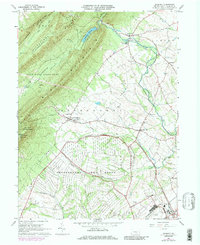
1966 Map of Roxbury
USGS Topo · Published 1986About this map
Letterkenny Army Depot occupies a significant portion of this landscape, its expansive grounds and U.S. Government Railroad spurs shaping the valley south of the towering ridges. To the north, Kittatinny Mountain and Blue Mountain form a massive natural barrier, overlooking the rural communities of Roxbury and Lurgan. The terrain is defined by the sharp contrast between the wooded slopes of the Buchanan State Forest and the agricultural lowlands drained by Conodoguinet Creek. Local life centers around small clusters of development like Upper Strasburg and Pleasant Hall, where a network of country schools and churches such as Emmanuel Ch and Salem Ch anchor the community. The presence of the Letterkenny Reservoir and numerous watercourses like Keasey Run underscore the region's reliance on the watershed flowing from the mountains into the Cumberland Valley.
Find a feature on this map
42 named features on this map. Tap any name to fly to it.
Don’t see what you’re looking for? This feature index may not catch every label — zoom into the map to look around manually.
Map Details
Editions of this 1966 Roxbury Map
4 editions found
Other maps of this area

1900 · Mercersburg
USGS Topo · 1:62,500

1902 · Chambersburg
USGS Topo · 1:62,500

1902 · Mercersburg
USGS Topo · 1:62,500

1923 · Shippensburg
USGS Topo · 1:62,500

1939 · Orbisonia
USGS Topo · 1:62,500

1940 · Orbisonia
USGS Topo · 1:62,500

1942 · Hagerstown
USGS Topo · 1:125,000

1943 · Hagerstown
USGS Topo · 1:125,000

1943 · Chambersburg
USGS Topo · 1:62,500

1943 · Mercersburg
USGS Topo · 1:62,500
Featured Places
- Lurgan Township, PA
- Metal Township, PA
- Letterkenny Township, PA
- Greene Township, PA
- Southampton Township, PA