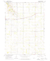
1963 Map of Royal
USGS Topo · Published 1977About this map
Verdigre Creek and its East Branch carve through the agricultural landscape of northern Antelope County, defining the drainage patterns for the townships of Verdigris and Eden. The village of Royal serves as the primary hub, situated along the tracks of the Chicago and North Western railroad. This rail corridor was central to the local economy, facilitating the movement of goods and people across the plains.
Find a feature on this map
17 named features on this map. Tap any name to fly to it.
Don’t see what you’re looking for? This feature index may not catch every label — zoom into the map to look around manually.
Map Details
Editions of this 1963 Royal Map
3 editions found
Other maps of this area

1955 · Sioux City
USGS Topo · 1:250,000

1955 · O'Neill
USGS Topo · 1:250,000

1958 · Sioux City
USGS Topo · 1:250,000

1959 · O'Neill
USGS Topo · 1:250,000

1959 · Sioux City
USGS Topo · 1:250,000

1963 · Orchard NE
USGS Topo · 1:24,000

1963 · Neligh
USGS Topo · 1:24,000

1963 · Brunswick
USGS Topo · 1:24,000

1963 · Royal
USGS Topo · 1:24,000

1963 · Orchard
USGS Topo · 1:24,000