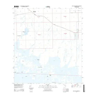
2015 Map of Royal Palm Hammock
USGS Topo · Published 2015About this map
The labyrinthine wetlands of the Ten Thousand Islands dominate this coastal landscape, where the transition from freshwater canals to saltwater bays defines the region's geography. Historically significant routes like the Tamiami Trl E slice through the northern section, following the Tamiami Canal Number C-4 across the southern Everglades. Small named locales such as Royal Palm Hammock, Old Grove, and Grocery Place provide specific points of reference for local historians and genealogists tracking settlement patterns in this part of Collier County. The complex network of waterways, including the Blackwater River, Whitney River, and Faka Union River, reveals the intricate drainage system feeding into larger bodies of water like Blackwater Bay and Pumpkin Bay. Further south, the map details numerous named keys and islands, such as Dismal Key, Jackfish Island, and Turtle Key, which are accessible only by boat through channels like Fakahatchee Pass.
Find a feature on this map
58 named features on this map. Tap any name to fly to it.
Don’t see what you’re looking for? This feature index may not catch every label — zoom into the map to look around manually.
Map Details
Editions of this 2015 Royal Palm Hammock Map
This is the sole edition of this map. No revisions or reprints were ever made.
Other maps of this area

1956 · Miami
USGS Topo · 1:250,000

1956 · West Palm Beach
USGS Topo · 1:250,000

1957 · West Palm Beach
USGS Topo · 1:250,000

1958 · West Palm Beach
USGS Topo · 1:250,000

1958 · Miami
USGS Topo · 1:250,000

1958 · Belle Meade
USGS Topo · 1:24,000

1958 · Belle Meade SE
USGS Topo · 1:24,000

1959 · Deep Lake SW
USGS Topo · 1:24,000

1972 · Weavers Station
USGS Topo · 1:24,000

1973 · Cape Romano
USGS Topo · 1:24,000