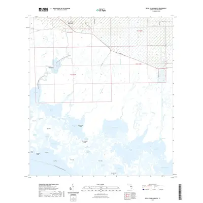
2021 Map of Royal Palm Hammock
USGS Topo · Published 2021About this map
Royal Palm Hammock stands at the northern edge of this coastal landscape, where the managed lands of Collier-Seminole State Park meet the labyrinthine waterways of the Everglades. The map captures a transition from land-based infrastructure along Tamiami Trl E and the Tamiami Canal Number One to the intricate mangrove systems of the Ten Thousand Islands. Early settlement traces are visible at Old Grove and Royal Palm Hammock Creek, while the vast network of saltwater estuaries includes Pumpkin Bay, Blackwater Bay, and Faka Union Bay. This coastal environment is defined by its reliance on water routes, featuring the Florida Circumnavigational Paddling Trl and the Blackwater River/Royal Palm Hammock Paddling Trl. Names like Coon Gravy Gate, Gill Rattle Creek, and Dismal Key Pass reflect the distinct local nomenclature of the Southwest Florida coast, providing researchers with specific geographic markers for the region's complex shoreline.
Find a feature on this map
64 named features on this map. Tap any name to fly to it.
Don’t see what you’re looking for? This feature index may not catch every label — zoom into the map to look around manually.
Map Details
Editions of this 2021 Royal Palm Hammock Map
This is the sole edition of this map. No revisions or reprints were ever made.
Other maps of this area

1956 · Miami
USGS Topo · 1:250,000

1956 · West Palm Beach
USGS Topo · 1:250,000

1957 · West Palm Beach
USGS Topo · 1:250,000

1958 · West Palm Beach
USGS Topo · 1:250,000

1958 · Miami
USGS Topo · 1:250,000

1958 · Belle Meade
USGS Topo · 1:24,000

1958 · Belle Meade SE
USGS Topo · 1:24,000

1959 · Deep Lake SW
USGS Topo · 1:24,000

1972 · Weavers Station
USGS Topo · 1:24,000

1973 · Cape Romano
USGS Topo · 1:24,000