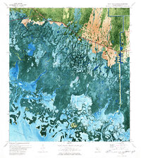
1973 Map of Royal Palm Hammock
USGS Topo · Published 1976About this map
Collier-Seminole State Park anchors the upper reaches of this orthophotomap, where the dry land of the Florida mainland begins to dissolve into the intricate coastal labyrinth of the Ten Thousand Islands. The Tamiami Trail cuts a sharp diagonal across the northern edge, serving as the primary corridor for travelers between the Gulf Coast and the interior. Along this route, the settlement at Royal Palm Hammock and the development at Remuda Ranch represent the sparse human footprint in an environment dominated by water and mangroves.
Find a feature on this map
41 named features on this map. Tap any name to fly to it.
Don’t see what you’re looking for? This feature index may not catch every label — zoom into the map to look around manually.
Map Details
Editions of this 1973 Royal Palm Hammock Map
This is the sole edition of this map. No revisions or reprints were ever made.
Other maps of this area

1956 · Miami
USGS Topo · 1:250,000

1956 · West Palm Beach
USGS Topo · 1:250,000

1957 · West Palm Beach
USGS Topo · 1:250,000

1958 · West Palm Beach
USGS Topo · 1:250,000

1958 · Miami
USGS Topo · 1:250,000

1958 · Belle Meade
USGS Topo · 1:24,000

1958 · Belle Meade SE
USGS Topo · 1:24,000

1959 · Deep Lake SW
USGS Topo · 1:24,000

1972 · Weavers Station
USGS Topo · 1:24,000

1973 · Cape Romano
USGS Topo · 1:24,000