1971 Map of Royalston
USGS Topo · Published 1981About this map
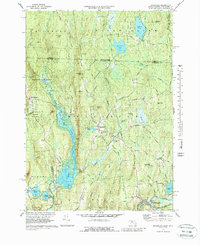
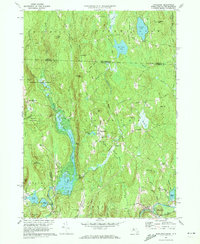
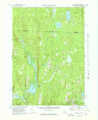
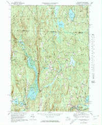
West Royalston and the central village of Royalston occupy a landscape defined by significant elevation changes and hydroelectric potential along the Massachusetts-New Hampshire border. The water system is dominated by the East Branch Tully River and the Tully Dam, which regulates Tully Lake. This 1971 revision of earlier surveys illustrates a transition toward conservation and forest management, with large tracts dedicated to the Royalston State Forest and Orange State Forest. Geologic and industrial features are scattered throughout, from the Gravel Pit near Beaver Brook to the dramatic cascades of Spirit Falls and Doane Falls. The southern portion of the quadrangle shows the concentrated settlement patterns of South Royalston and Fryeville, where the Boston and Maine railroad tracks follow the course of the Millers River. Genealogy researchers will find several well-marked burial sites, including Center Cem and Riverside Cem.
Find a feature on this map
67 named features on this map. Tap any name to fly to it.
Don’t see what you’re looking for? This feature index may not catch every label — zoom into the map to look around manually.
Map Details
Editions of this 1971 Royalston Map
5 editions found

Other maps of this area

1887 · Warwick
USGS Topo · 1:62,500

1887 · Winchendon
USGS Topo · 1:62,500

1889 · Warwick
USGS Topo · 1:62,500

1890 · Winchendon
USGS Topo · 1:62,500

1894 · Winchendon
USGS Topo · 1:62,500

1894 · Warwick
USGS Topo · 1:62,500

1898 · Monadnock
USGS Topo · 1:62,500

1898 · Keene
USGS Topo · 1:62,500

1932 · Warwick
USGS Topo · 1:48,000

1932 · Winchendon
USGS Topo · 1:48,000