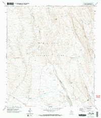
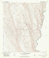
1971 Map of Roys Peak
USGS Topo · Published 1974About this map
Tornillo Creek carves a central path through this arid portion of Big Bend National Park, revealing a landscape defined by dramatic geological formations and essential water sources. The Sierra Del Carmen and the towering Alto Relex dominate the eastern topography, while the Mc Kinney Hills rise to the north. Historical transit is etched into the terrain via the Old Ore Road and various pack trails that connected isolated outposts like Dugout and the Ruins found near the creek bed. Strategic water points, including Carlota Tinaja and Ernst Tinaja, provide evidence of the vital resources required for desert survival and travel. The presence of the Banta Shut-in and Estufa Canyon highlights the erosion-carved nature of the Trans-Pecos region during the early 1970s.
Find a feature on this map
20 named features on this map. Tap any name to fly to it.
Don’t see what you’re looking for? This feature index may not catch every label — zoom into the map to look around manually.
Map Details
Editions of this 1971 Roys Peak Map
2 editions found
Other maps of this area

1903 · Chisos Mountains
USGS Topo · 1:125,000

1905 · Chisos Mountains
USGS Topo · 1:125,000

1930 · Stillwell Creek
USGS Topo · 1:62,500

1959 · Emory Peak
USGS Topo · 1:250,000

1965 · Emory Peak
USGS Topo · 1:250,000

1971 · Glenn Spring
USGS Topo · 1:24,000
1971 · McKinney Springs
USGS Topo · 1:24,000
1971 · Grapevine Hills
USGS Topo · 1:24,000
1971 · Ernst Valley
USGS Topo · 1:24,000
1971 · Boquillas
USGS Topo · 1:24,000