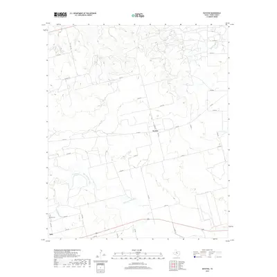
2019 Map of Royston
USGS Topo · Published 2019About this map
Royston sits atop a rise in the north-central portion of this Fisher County landscape, where the local road network of farm-to-market routes and county roads connects scattered rural homesteads. The terrain is defined by the winding course of the Clear Fork Brazos River, which cuts through the southern half of the quadrangle. Significant water sources like Kyle Spring and the drainage of Sandy Cr suggest the importance of reliable water in this part of West Texas. To the southwest, the town of Roby is partially visible, anchored by the Roby Cem. The map reveals a highly structured agricultural landscape, where numbered county roads like Co RD 212 and Co RD 216 trace the boundaries of large land parcels. The seasonal flow of California Cr and Cottonwood Cr further illustrates the drainage patterns that have shaped local ranching and farming practices for generations.
Find a feature on this map
33 named features on this map. Tap any name to fly to it.
Don’t see what you’re looking for? This feature index may not catch every label — zoom into the map to look around manually.
Map Details
Editions of this 2019 Royston Map
This is the sole edition of this map. No revisions or reprints were ever made.
Other maps of this area

1893 · Roby
USGS Topo · 1:125,000

1926 · Roby 2-b
USGS Topo · 1:48,000

1931 · Rotan
USGS Topo · 1:62,500

1954 · Big Spring
USGS Topo · 1:250,000

1957 · Noodle
USGS Topo · 1:62,500

1958 · Big Spring
USGS Topo · 1:250,000
1965 · Hamlin NW
USGS Topo · 1:24,000

1965 · McCaulley
USGS Topo · 1:24,000
1969 · White Canyon
USGS Topo · 1:24,000
1969 · Poke Mountain
USGS Topo · 1:24,000