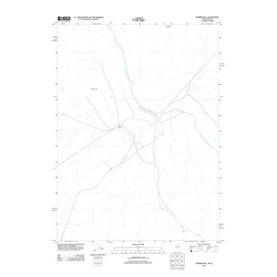
2012 Map of Rubber Hill
USGS Topo · Published 2012About this map
South Fork Owyhee River carves through the high desert landscape of Elko County, defining the drainage patterns and historical ranching utility of this border region between Nevada and Idaho. The map reveals a sparse network of unpaved roads and tracks that converge near Devils Corral, a site suggesting early livestock management or tactical use of the local topography. To the northwest, the namesake Rubber Hill stands as a prominent geographic landmark overlooking the river's winding course. This 2012 survey illustrates the continued importance of water sources in an arid environment, noting features such as Coyote Springs and the Stateline Windmill, which mark essential points for survival and industry along the state boundary.
Find a feature on this map
5 named features on this map. Tap any name to fly to it.
Don’t see what you’re looking for? This feature index may not catch every label — zoom into the map to look around manually.
Map Details
Editions of this 2012 Rubber Hill Map
This is the sole edition of this map. No revisions or reprints were ever made.
Other maps of this area

1955 · McDermitt
USGS Topo · 1:250,000

1955 · Jordan Valley
USGS Topo · 1:250,000

1957 · Jordan Valley
USGS Topo · 1:250,000

1958 · Jordan Valley
USGS Topo · 1:250,000

1959 · McDermitt
USGS Topo · 1:250,000

1973 · Coyote Hole
USGS Topo · 1:24,000

1973 · Bull Camp Butte
USGS Topo · 1:24,000
1973 · Star Valley Ridge East
USGS Topo · 1:24,000
1973 · Rubber Hill
USGS Topo · 1:24,000

1973 · Twelvemile Flat
USGS Topo · 1:24,000