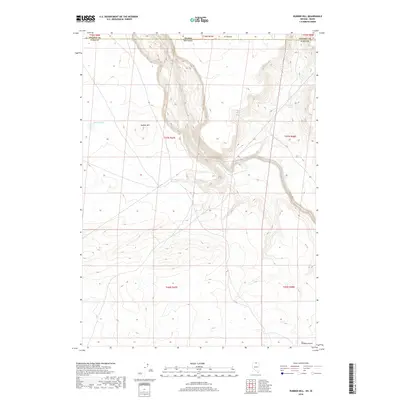
2018 Map of Rubber Hill
USGS Topo · Published 2018About this map
South Fork Owyhee River snakes through the high desert floor as it crosses from Nevada into Idaho, carving a deep canyon corridor through this corner of Elko County. The landscape is defined by its arid basins and volcanic rises, most notably Rubber Hill and the adjacent seasonal waters of Rubber Lake. This 2018 survey captures the borderlands where the Y-P Desert and the Owyhee Desert meet, a region largely undisturbed by modern development. Significant for those studying the hydrology of the Great Basin, the map identifies vital water sources such as Coyote Springs and the complex drainage patterns feeding into the Owyhee watershed. The survey provides a clear view of the Public Land Survey System grid, including T47N R47E and T16S R3W, marking the transition from Nevada's northern reaches into Owyhee County, Idaho.
Find a feature on this map
16 named features on this map. Tap any name to fly to it.
Don’t see what you’re looking for? This feature index may not catch every label — zoom into the map to look around manually.
Map Details
Editions of this 2018 Rubber Hill Map
This is the sole edition of this map. No revisions or reprints were ever made.
Other maps of this area

1955 · McDermitt
USGS Topo · 1:250,000

1955 · Jordan Valley
USGS Topo · 1:250,000

1957 · Jordan Valley
USGS Topo · 1:250,000

1958 · Jordan Valley
USGS Topo · 1:250,000

1959 · McDermitt
USGS Topo · 1:250,000

1973 · Coyote Hole
USGS Topo · 1:24,000

1973 · Bull Camp Butte
USGS Topo · 1:24,000
1973 · Star Valley Ridge East
USGS Topo · 1:24,000
1973 · Rubber Hill
USGS Topo · 1:24,000

1973 · Twelvemile Flat
USGS Topo · 1:24,000