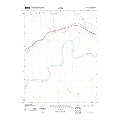
2010 Map of Ruby Canyon
USGS Topo · Published 2010About this map
Ruby Canyon serves as the centerpiece of this desert landscape where the Colorado River carves through the sandstone plateaus of Mesa County. The river’s path is marked by distinctive riparian areas like Crow Bottom and Moore Bottom, flanked by high-walled side canyons including Horsethief Canyon and Mee Canyon. This 2010 survey highlights a remote recreational and water-management corridor, featuring the Kokopelli Trl and the water infrastructure of the 6 and 50 Reservoir and its associated 6 and 50 Retention Dam. Geologic landmarks such as the Will Minor Arch and the dark formations at Black Rocks reveal the complex topography that defines Rabbit Valley. The map records a moment where modern trails and interstate travel intersect with ancient drainage systems like Salt Creek and McDonald Creek.
Find a feature on this map
21 named features on this map. Tap any name to fly to it.
Don’t see what you’re looking for? This feature index may not catch every label — zoom into the map to look around manually.
Map Details
Editions of this 2010 Ruby Canyon Map
This is the sole edition of this map. No revisions or reprints were ever made.
Other maps of this area

1885 · East Tavaputs
USGS Topo · 1:250,000

1956 · Westwater 4 SE
USGS Topo · 1:24,000

1956 · Grand Junction
USGS Topo · 1:250,000

1959 · Grand Junction
USGS Topo · 1:250,000

1960 · Grand Junction
USGS Topo · 1:250,000

1962 · Grand Junction
USGS Topo · 1:250,000

1962 · Mack
USGS Topo · 1:24,000
1962 · Battleship Rock
USGS Topo · 1:24,000

1964 · Grand Junction
USGS Topo · 1:250,000

1965 · Grand Junction
USGS Topo · 1:250,000