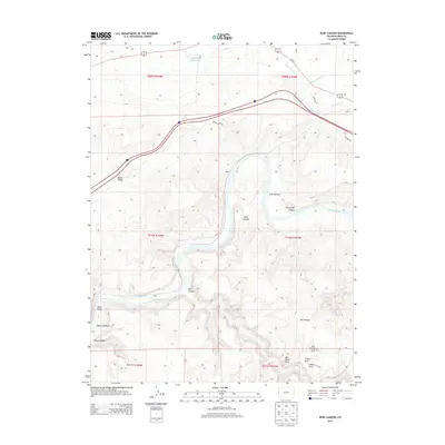
2013 Map of Ruby Canyon
USGS Topo · Published 2013About this map
The Colorado River carves a deep, winding path through this corner of Mesa County, creating the dramatic geological formations of Ruby Canyon and Horsethief Canyon. This 2013 survey illustrates a landscape defined by sharp elevation changes and high desert drainage systems like Salt Creek and Mack Wash. North of the river, Rabbit Valley serves as a prominent geographic basin, while the southern reaches of the map are notable for a concentration of named natural bridges, including Two Feathers Arch, Will Minor Arch, and Crown Arch. The presence of the 6 and 50 Reservoir in the north and the expansive Moore Bottom along the riverbank suggests a terrain where water management and access are central to the land's utility. Significant landmarks such as Black Rocks and Shale further indicate the diverse geological strata exposed by the river's eons of erosion.
Find a feature on this map
32 named features on this map. Tap any name to fly to it.
Don’t see what you’re looking for? This feature index may not catch every label — zoom into the map to look around manually.
Map Details
Editions of this 2013 Ruby Canyon Map
This is the sole edition of this map. No revisions or reprints were ever made.
Other maps of this area

1885 · East Tavaputs
USGS Topo · 1:250,000

1956 · Westwater 4 SE
USGS Topo · 1:24,000

1956 · Grand Junction
USGS Topo · 1:250,000

1959 · Grand Junction
USGS Topo · 1:250,000

1960 · Grand Junction
USGS Topo · 1:250,000

1962 · Grand Junction
USGS Topo · 1:250,000

1962 · Mack
USGS Topo · 1:24,000
1962 · Battleship Rock
USGS Topo · 1:24,000

1964 · Grand Junction
USGS Topo · 1:250,000

1965 · Grand Junction
USGS Topo · 1:250,000