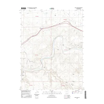
2016 Map of Ruby Canyon
USGS Topo · Published 2016About this map
The Colorado River carves a deep, winding course through the high desert of western Colorado in this 2016 survey, creating the dramatic geological formations of Ruby Canyon. This landscape is defined by its vertical relief and natural stone features, including several named spans such as Two Feathers Arch, Crown Arch, and Will Minor Arch near the southern boundary. The topography reveals a complex network of canyons and flatlands, from the broad Rabbit Valley and Grand Valley in the north to the low-lying Moore Bottom and Crow Bottom along the riverbanks. Modern recreational use is evident through a sophisticated network of paths like the Kokopelli Trl and various loops such as Steve's Loop and Lion's Loop, which navigate the high ridges and canyon rims. Historic access routes and primitive roads like Rabbit Valley 8 and Troy Built trace the old travel corridors through this remote portion of Mesa County.
Find a feature on this map
41 named features on this map. Tap any name to fly to it.
Don’t see what you’re looking for? This feature index may not catch every label — zoom into the map to look around manually.
Map Details
Editions of this 2016 Ruby Canyon Map
This is the sole edition of this map. No revisions or reprints were ever made.
Other maps of this area

1885 · East Tavaputs
USGS Topo · 1:250,000

1956 · Westwater 4 SE
USGS Topo · 1:24,000

1956 · Grand Junction
USGS Topo · 1:250,000

1959 · Grand Junction
USGS Topo · 1:250,000

1960 · Grand Junction
USGS Topo · 1:250,000

1962 · Grand Junction
USGS Topo · 1:250,000

1962 · Mack
USGS Topo · 1:24,000
1962 · Battleship Rock
USGS Topo · 1:24,000

1964 · Grand Junction
USGS Topo · 1:250,000

1965 · Grand Junction
USGS Topo · 1:250,000