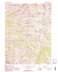
1990 Map of Ruby Dome
USGS Topo · Published 1991About this map
Ruby Dome and Mount Silliman anchor the high-altitude landscape of this 1990 survey of the Ruby Mountains. The map illustrates a complex alpine environment defined by deep glacial gouges like Echo Canyon and Box Canyon, where numerous high-country basins hold water bodies such as Island Lake, Lamoille Lake, and Echo Lake. Human activity in these heights is primarily limited to mineral exploration and recreation, represented by several prospects, the American Beauty Mine, and the Battle Creek Mines located in the southern reaches. The entire area is protected within the Humboldt National Forest and the Ruby Mountains Wilderness, with the high crest accessible via a network of pack trails that cross Liberty Pass to connect isolated basins like those holding Castle Lake and North Furlong Lake. This transitional period map captures the terrain just as modern wilderness management was being codified.
Find a feature on this map
45 named features on this map. Tap any name to fly to it.
Don’t see what you’re looking for? This feature index may not catch every label — zoom into the map to look around manually.
Map Details
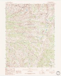
Editions of this 1990 Ruby Dome Map
2 editions found
Other maps of this area

1934 · Jiggs
USGS Topo · 1:125,000

1935 · Halleck
USGS Topo · 1:125,000

1937 · Jiggs
USGS Topo · 1:125,000

1955 · Elko
USGS Topo · 1:250,000

1958 · Elko
USGS Topo · 1:250,000

1959 · Jiggs
USGS Topo · 1:62,500

1962 · Elko
USGS Topo · 1:250,000

1962 · Lee
USGS Topo · 1:62,500

1962 · Lamoille
USGS Topo · 1:62,500

1965 · Elko
USGS Topo · 1:250,000