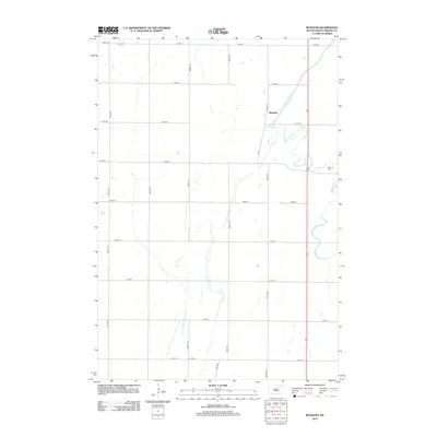
2012 Map of Rudolph
USGS Topo · Published 2012About this map
Moccasin Cr meanders through the eastern edge of this Brown County landscape, defining the local geography as it winds past the small settlement of Rudolph. The area is characterized by a precise grid of agricultural roads, including 385th Ave and 141st St, which partition the prairie into large, productive tracts. This 2012 survey illustrates the enduring rural structure of Warner Township, where the Warner Cem sits near the eastern boundary, serving as a significant landmark for those tracing local family histories. The lack of dense urbanization highlights the region's continued focus on large-scale farming and the natural drainage patterns provided by the creek system.
Find a feature on this map
18 named features on this map. Tap any name to fly to it.
Don’t see what you’re looking for? This feature index may not catch every label — zoom into the map to look around manually.
Map Details
Editions of this 2012 Rudolph Map
This is the sole edition of this map. No revisions or reprints were ever made.
Other maps of this area

1895 · Aberdeen
USGS Topo · 1:125,000

1899 · Northville
USGS Topo · 1:125,000

1953 · Warner
USGS Topo · 1:24,000

1954 · Mellette
USGS Topo · 1:24,000

1954 · Aberdeen
USGS Topo · 1:250,000

1956 · Aberdeen
USGS Topo · 1:250,000
1960 · Aberdeen East
USGS Topo · 1:24,000

1960 · Aberdeen West
USGS Topo · 1:24,000

1960 · Rudolph
USGS Topo · 1:24,000
1960 · Northville
USGS Topo · 1:24,000