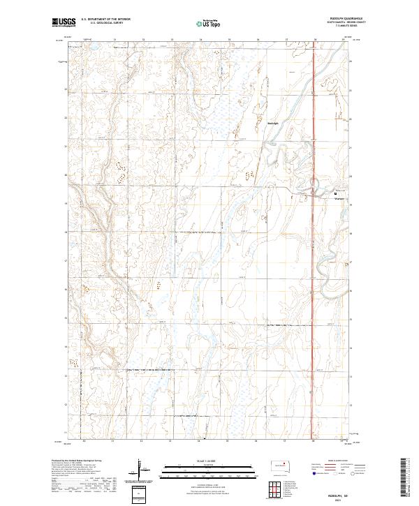
2021 Map of Rudolph
USGS Topo · Published 2021About this map
Moccasin Creek meanders through the eastern section of this Brown County landscape, defining the local drainage and topography. The settlement of Warner serves as a primary hub on the eastern edge of the quadrangle, where residential patterns congregate near the Warner Cem. Further north along the transit corridor, the location of Rudolph indicates a smaller point of interest within the expansive section lines of the Public Land Survey System, which organizes the region into a strictly rectilinear grid of townships and ranges. This 2021 update illustrates the persistent rural character of the area, where a dense network of county roads like Co Rd 23 and 386th Ave facilitates access to individual agricultural sections. The map provides a precise look at the drainage patterns of the James River valley periphery, marked by numerous small wetlands and intermittent water features scattered between the main channel of the creek.
Find a feature on this map
26 named features on this map. Tap any name to fly to it.
Don’t see what you’re looking for? This feature index may not catch every label — zoom into the map to look around manually.
Map Details
Editions of this 2021 Rudolph Map
This is the sole edition of this map. No revisions or reprints were ever made.
Other maps of this area

1895 · Aberdeen
USGS Topo · 1:125,000

1899 · Northville
USGS Topo · 1:125,000

1953 · Warner
USGS Topo · 1:24,000

1954 · Mellette
USGS Topo · 1:24,000

1954 · Aberdeen
USGS Topo · 1:250,000

1956 · Aberdeen
USGS Topo · 1:250,000
1960 · Aberdeen East
USGS Topo · 1:24,000

1960 · Aberdeen West
USGS Topo · 1:24,000

1960 · Rudolph
USGS Topo · 1:24,000
1960 · Northville
USGS Topo · 1:24,000