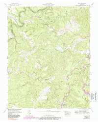
1952 Map of Rugby
USGS Topo · Published 1988About this map
The settlement of Rugby, a site of significant cultural and social history, occupies the high ground above the Clear Fork river within this topographic record. The landscape is defined by the sharp boundaries of Morgan, Scott, and Fentress Counties, where the terrain transitions into complex hollows like Polecat Hollow and prominent elevations such as Potato Knob. The railway economy is evident along the Southern line, which services the community of Sunbright and passes through the Sixteen Tunnel near Huffman. Local genealogy is well-represented through numerous family-named burial grounds, including Lewallen Cem, Griffith Cem, and Pemberton Cem. The presence of Strip mines and Oil wells near Glenmary indicates the industrial footprint on the land during this period, while the winding course of White Oak Creek and the dramatic Horseshoe Bend characterize the area's natural drainage patterns.
Find a feature on this map
46 named features on this map. Tap any name to fly to it.
Don’t see what you’re looking for? This feature index may not catch every label — zoom into the map to look around manually.
Map Details
Editions of this 1952 Rugby Map
4 editions found

Other maps of this area

1895 · Wartburg
USGS Topo · 1:125,000

1896 · Wartburg
USGS Topo · 1:125,000

1935 · Gobey
USGS Topo · 1:24,000

1935 · Pilot Mountain
USGS Topo · 1:24,000

1936 · Twin Bridges
USGS Topo · 1:24,000

1943 · Twin Bridges
USGS Topo · 1:24,000
1945 · Twin Bridges
USGS Topo · 1:24,000
1946 · Gobey
USGS Topo · 1:24,000
1946 · Pilot Mountain
USGS Topo · 1:24,000

1952 · Helenwood
USGS Topo · 1:24,000