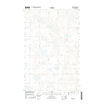
2014 Map of Rugby NE
USGS Topo · Published 2014About this map
Glacial depressions and prairie potholes characterize this portion of Pierce County, where water bodies like Sand Lake and Guss Lake sit amidst a fine-tuned grid of rural roads. The landscape is defined by its section-line infrastructure, including thoroughfares such as 37th Ave NE and 74th St NE, which facilitate movement through this agricultural heartland. This 2014 survey by the U.S. Geological Survey shows the persistence of traditional land divisions in the modern era, where the placement of 67th St NE and 42nd Ave NE reflects the enduring geometry of the Great Plains. The map's contour intervals reveal subtle topographic variations that govern the drainage into numerous unnamed marshlands and temporary pools typical of the North Dakota drift prairie.
Find a feature on this map
16 named features on this map. Tap any name to fly to it.
Don’t see what you’re looking for? This feature index may not catch every label — zoom into the map to look around manually.
Map Details
Editions of this 2014 Rugby NE Map
This is the sole edition of this map. No revisions or reprints were ever made.
Other maps of this area

1953 · Devils Lake
USGS Topo · 1:250,000

1954 · Rugby NW
USGS Topo · 1:24,000

1955 · Rugby
USGS Topo · 1:24,000

1955 · Rolette SW
USGS Topo · 1:24,000

1956 · Devils Lake
USGS Topo · 1:250,000

1971 · Wolford
USGS Topo · 1:24,000

1971 · Island Lake
USGS Topo · 1:24,000

1971 · Knox
USGS Topo · 1:24,000

1971 · Rugby NE
USGS Topo · 1:24,000
1971 · Pleasant Lake
USGS Topo · 1:24,000