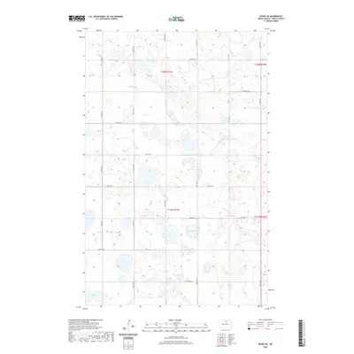
2020 Map of Rugby NE
USGS Topo · Published 2020About this map
Sand Lake serves as the focal point of this glaciated prairie landscape in Pierce County, where a network of section-line roads defines the agrarian layout of the early 21st century. The map reveals the precise Public Land Survey System organization of Townships t158n r71w and t157n r71w, showcasing how North Dakota's rural geography remains anchored to its foundational survey grid. Numerous small prairie potholes and wetlands are scattered across the terrain, illustrating the complex local hydrology that surrounds named thoroughfares like 74th St NE and 40th Ave NE. This cartographic record is particularly useful for understanding modern property access and the persistent nature of North Dakota's rural road systems, which continue to follow the rigid lines established over a century ago.
Find a feature on this map
18 named features on this map. Tap any name to fly to it.
Don’t see what you’re looking for? This feature index may not catch every label — zoom into the map to look around manually.
Map Details
Editions of this 2020 Rugby NE Map
This is the sole edition of this map. No revisions or reprints were ever made.
Other maps of this area

1953 · Devils Lake
USGS Topo · 1:250,000

1954 · Rugby NW
USGS Topo · 1:24,000

1955 · Rugby
USGS Topo · 1:24,000

1955 · Rolette SW
USGS Topo · 1:24,000

1956 · Devils Lake
USGS Topo · 1:250,000

1971 · Wolford
USGS Topo · 1:24,000

1971 · Island Lake
USGS Topo · 1:24,000

1971 · Knox
USGS Topo · 1:24,000

1971 · Rugby NE
USGS Topo · 1:24,000
1971 · Pleasant Lake
USGS Topo · 1:24,000