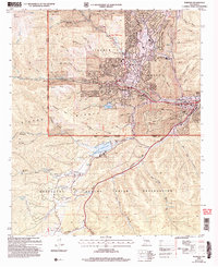
2004 Map of Ruidoso
USGS Topo · Published 2006About this map
Ruidoso serves as the central hub of this mountain landscape, where the Middle Fork Rio Ruidoso and South Fork Rio Ruidoso converge. The town's layout is defined by its canyon topography, with development following the paths of Smokey Bear Blvd and Sudderth Drive. To the north, Alpine Village and Ponderosa Heights sit nestled against the Lincoln National Forest, while the southern portion of the map is dominated by the Mescalero Apache Indian Reservation. This area features prominent landmarks such as the Inn of the Mountain Gods overlooking Mescalero Lake. Recreation and industry intersect here, visible through the Golf Course and Ruidoso High School near the town center, and a Mine and Quarry located in the surrounding Grindstone Mesa and Dude Mesa.
Find a feature on this map
48 named features on this map. Tap any name to fly to it.
Don’t see what you’re looking for? This feature index may not catch every label — zoom into the map to look around manually.
Map Details
Editions of this 2004 Ruidoso Map
This is the sole edition of this map. No revisions or reprints were ever made.
Other maps of this area

1950 · Sierra Blanca Peak
USGS Topo · 1:62,500

1950 · Mescalero
USGS Topo · 1:62,500

1955 · Roswell
USGS Topo · 1:250,000

1958 · Roswell
USGS Topo · 1:250,000

1962 · Roswell
USGS Topo · 1:250,000

1963 · Fort Stanton
USGS Topo · 1:24,000

1963 · Ruidoso Downs
USGS Topo · 1:24,000

1963 · Ruidoso
USGS Topo · 1:24,000

1963 · Angus
USGS Topo · 1:24,000

1963 · Apache Summit
USGS Topo · 1:24,000