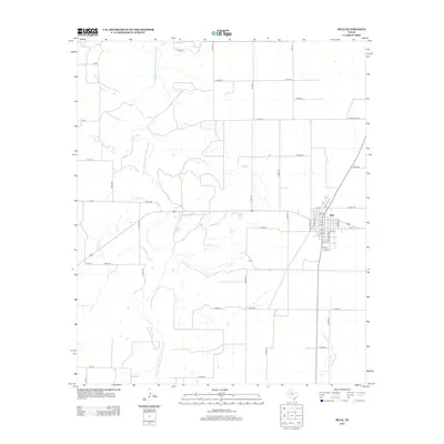
2013 Map of Rule
USGS Topo · Published 2013About this map
Rule sits as the primary settlement in this West Texas landscape, defined by a grid of agricultural section roads and the meandering path of the Double Mountain Fork Brazos River. The town itself is meticulously detailed, showing a street plan from 1st St through 10th St, anchored by Fm-617. The surrounding terrain is drained by several seasonal waterways, including Tonk Cr, Mulberry Cr, and Willow Cr, which cut through the ranching and farming acreage. The map records the contemporary infrastructure of Haskell County, where traditional county roads like Co Rd-148 and Co Rd-460 intersect with state-maintained routes like Ranch Road 617, illustrating the enduring spatial organization of this rural community.
Find a feature on this map
51 named features on this map. Tap any name to fly to it.
Don’t see what you’re looking for? This feature index may not catch every label — zoom into the map to look around manually.
Map Details
Editions of this 2013 Rule Map
This is the sole edition of this map. No revisions or reprints were ever made.
Other maps of this area

1925 · Aspermont 4-a
USGS Topo · 1:48,000

1925 · Haskell 3-b
USGS Topo · 1:48,000

1931 · Aspermont
USGS Topo · 1:62,500

1954 · Lubbock
USGS Topo · 1:250,000

1954 · Wichita Falls
USGS Topo · 1:250,000

1958 · Wichita Falls
USGS Topo · 1:250,000

1962 · Kiowa Peak
USGS Topo · 1:24,000
1962 · Frog Mountain
USGS Topo · 1:24,000

1964 · Sagerton
USGS Topo · 1:24,000

1965 · Jud
USGS Topo · 1:24,000