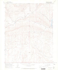
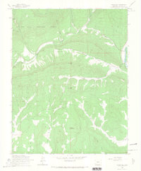
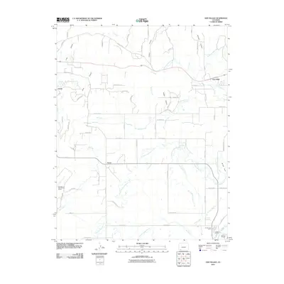
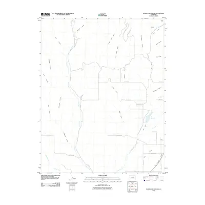
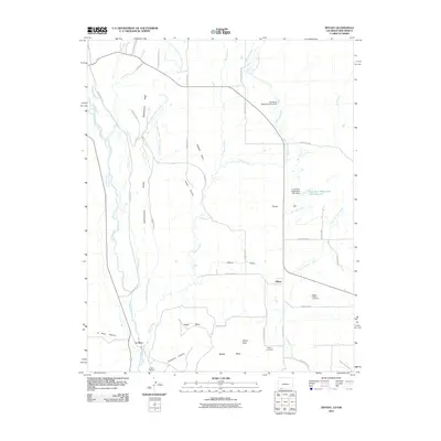
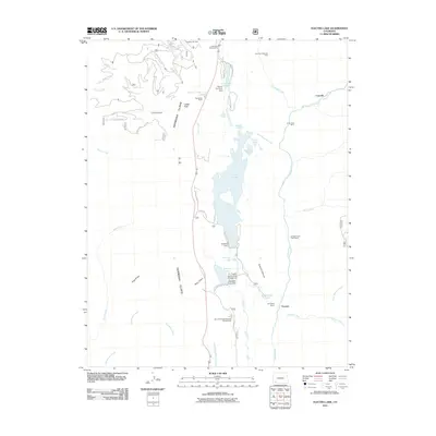
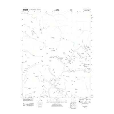
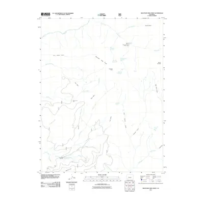
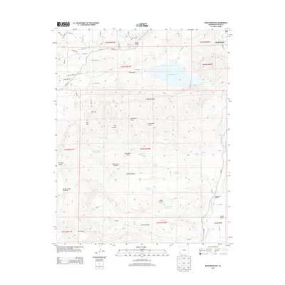
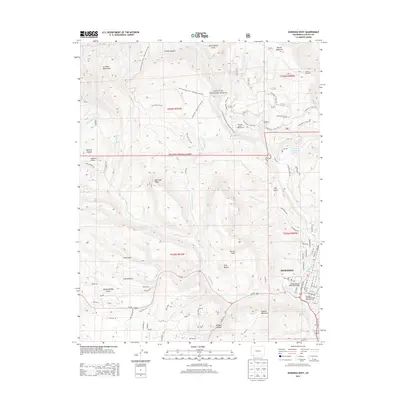
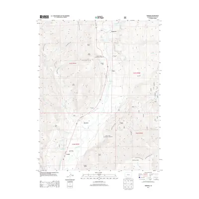
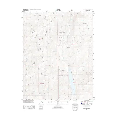
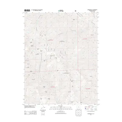
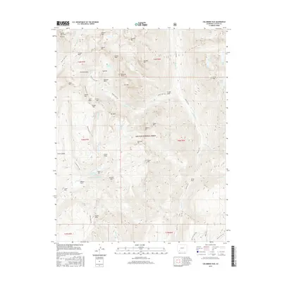
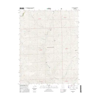
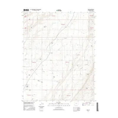
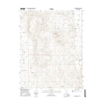
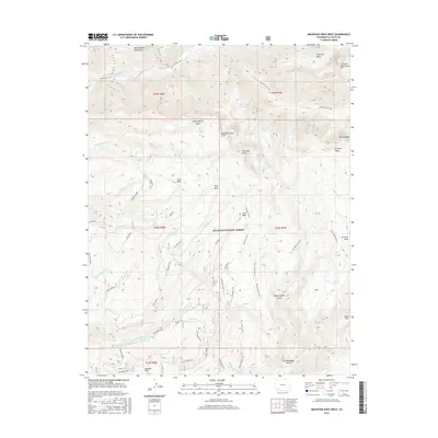
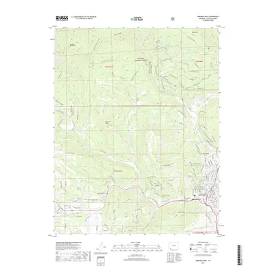
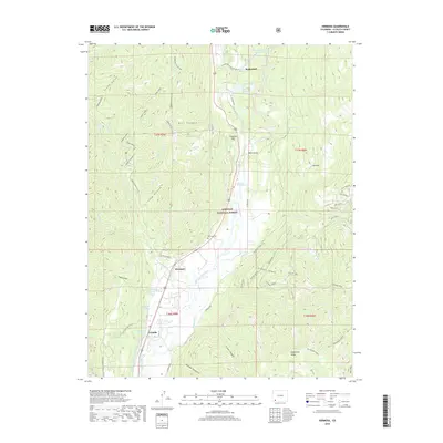
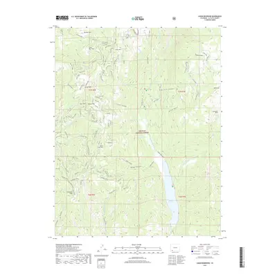
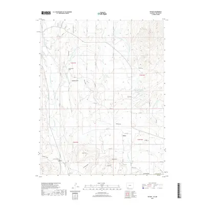
1964 Map of Rules Hill
USGS Topo · Published 1967About this map
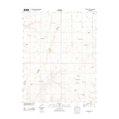
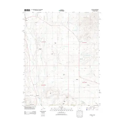
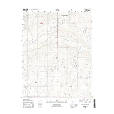
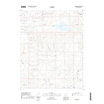
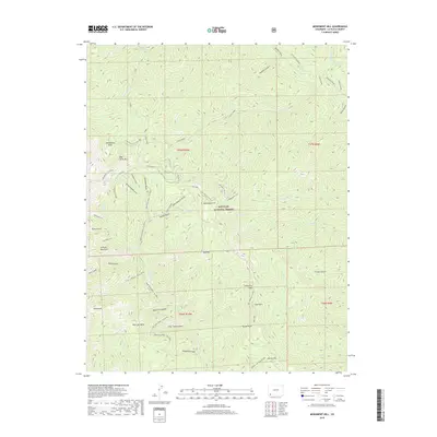
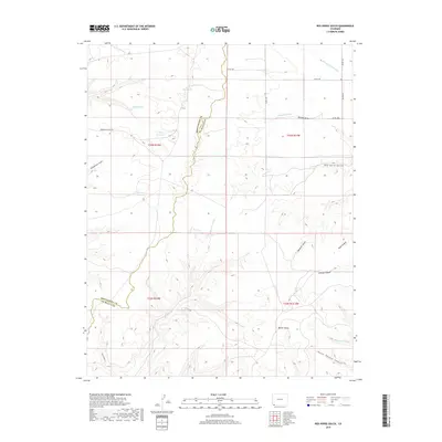
The San Juan National Forest provides the backdrop for this mid-1960s study of the high-elevation terrain near the Los Pinos River. The landscape is defined by the convergence of several major waterways, including the North Fork and South Fork Florida Rivers, which carve through the mountains toward Elks Park. Notable for local researchers is the presence of the Shrock Cem near the headwaters of the Florida River, a distinct marker of early inhabitants in this mountainous region. Settlement is sparse, represented by the small community of Columbus and the topographic high points of Rules Hill and Rabbit Mountain. Evidence of early land management and transportation is found in the Sullivan Ditch and the Vosburg Pike, while numerous unnamed Jeep Trails snake across the canyons, indicating the area's continued use for resource management and backcountry access.
Find a feature on this map
26 named features on this map. Tap any name to fly to it.
Don’t see what you’re looking for? This feature index may not catch every label — zoom into the map to look around manually.
Map Details
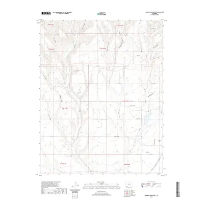
Editions of this 1964 Rules Hill Map
3 editions found
Historical Maps of Columbus Through Time
166 maps found

1895 La Plata
La Plata County, CO

1897 La Plata
La Plata County, CO

1898 Engineer Mountain
La Plata County, CO

1899 La Plata
La Plata County, CO

1900 Engineer Mountain
La Plata County, CO

1900 Needle Mountains
La Plata County, CO

1902 Needle Mountains
La Plata County, CO

1908 Engineer Mountain
La Plata County, CO

1908 La Plata
La Plata County, CO

1913 Red Mesa
La Plata County, CO

1960 Electra Lake
La Plata County, CO

1960 Elk Creek
La Plata County, CO

1963 Durango East
La Plata County, CO

1963 Durango West
La Plata County, CO

1963 Hermosa
La Plata County, CO

1963 Hesperus
La Plata County, CO

1963 La Plata
La Plata County, CO

1963 Monument Hill
La Plata County, CO

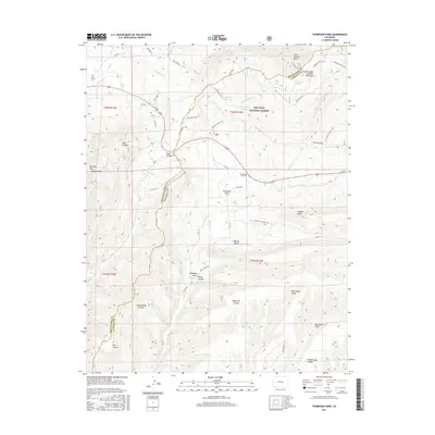
1963 Thompson Park
La Plata County, CO

1964 Lemon Reservoir
La Plata County, CO

1964 Ludwig Mountain
La Plata County, CO

1964 Rules Hill
La Plata County, CO

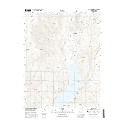
1964 Vallecito Reservoir
La Plata County, CO

1966 Red Horse Gulch
La Plata County, CO

1968 Basin Mountain
La Plata County, CO

1968 Bondad Hill
La Plata County, CO

1968 Gem Village
La Plata County, CO

1968 Kline
La Plata County, CO

1968 Loma Linda
La Plata County, CO

1968 Long Mountain
La Plata County, CO

1968 Mormon Reservoir
La Plata County, CO

1968 Pinkerton Mesa
La Plata County, CO

1968 Redmesa
La Plata County, CO

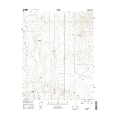
1968 Tiffany
La Plata County, CO

1973 Columbine Pass
La Plata County, CO

1973 Mountain View Crest
La Plata County, CO
2010 Basin Mountain
La Plata County, CO
2010 Bondad Hill
La Plata County, CO
2010 Gem Village
La Plata County, CO
2010 Kline
La Plata County, CO
2010 Loma Linda
La Plata County, CO
2010 Long Mountain
La Plata County, CO
2010 Mormon Reservoir
La Plata County, CO
2010 Pinkerton Mesa
La Plata County, CO
2010 Red Horse Gulch
La Plata County, CO
2010 Redmesa
La Plata County, CO
2010 Tiffany
La Plata County, CO
2011 Columbine Pass
La Plata County, CO
2011 Durango East
La Plata County, CO
2011 Durango West
La Plata County, CO
2011 Electra Lake
La Plata County, CO
2011 Elk Creek
La Plata County, CO
2011 Hermosa
La Plata County, CO
2011 Hesperus
La Plata County, CO
2011 La Plata
La Plata County, CO
2011 Lemon Reservoir
La Plata County, CO
2011 Ludwig Mountain
La Plata County, CO
2011 Monument Hill
La Plata County, CO
2011 Mountain View Crest
La Plata County, CO
2011 Rules Hill
La Plata County, CO
2011 Thompson Park
La Plata County, CO
2011 Vallecito Reservoir
La Plata County, CO
2013 Basin Mountain
La Plata County, CO
2013 Bondad Hill
La Plata County, CO
2013 Columbine Pass
La Plata County, CO
2013 Durango East
La Plata County, CO
2013 Durango West
La Plata County, CO
2013 Electra Lake
La Plata County, CO
2013 Elk Creek
La Plata County, CO
2013 Gem Village
La Plata County, CO
2013 Hermosa
La Plata County, CO
2013 Hesperus
La Plata County, CO
2013 Kline
La Plata County, CO
2013 La Plata
La Plata County, CO
2013 Lemon Reservoir
La Plata County, CO
2013 Loma Linda
La Plata County, CO
2013 Long Mountain
La Plata County, CO
2013 Ludwig Mountain
La Plata County, CO
2013 Monument Hill
La Plata County, CO
2013 Mormon Reservoir
La Plata County, CO
2013 Mountain View Crest
La Plata County, CO
2013 Pinkerton Mesa
La Plata County, CO
2013 Red Horse Gulch
La Plata County, CO
2013 Redmesa
La Plata County, CO
2013 Rules Hill
La Plata County, CO
2013 Thompson Park
La Plata County, CO
2013 Tiffany
La Plata County, CO
2013 Vallecito Reservoir
La Plata County, CO
2016 Basin Mountain
La Plata County, CO
2016 Bondad Hill
La Plata County, CO
2016 Columbine Pass
La Plata County, CO
2016 Durango East
La Plata County, CO
2016 Durango West
La Plata County, CO
2016 Electra Lake
La Plata County, CO
2016 Elk Creek
La Plata County, CO
2016 Gem Village
La Plata County, CO
2016 Hermosa
La Plata County, CO
2016 Hesperus
La Plata County, CO
2016 Kline
La Plata County, CO
2016 La Plata
La Plata County, CO
2016 Lemon Reservoir
La Plata County, CO
2016 Loma Linda
La Plata County, CO
2016 Long Mountain
La Plata County, CO
2016 Ludwig Mountain
La Plata County, CO
2016 Monument Hill
La Plata County, CO
2016 Mormon Reservoir
La Plata County, CO
2016 Mountain View Crest
La Plata County, CO
2016 Pinkerton Mesa
La Plata County, CO
2016 Red Horse Gulch
La Plata County, CO
2016 Redmesa
La Plata County, CO
2016 Rules Hill
La Plata County, CO
2016 Thompson Park
La Plata County, CO
2016 Tiffany
La Plata County, CO
2016 Vallecito Reservoir
La Plata County, CO
2019 Basin Mountain
La Plata County, CO
2019 Bondad Hill
La Plata County, CO
2019 Columbine Pass
La Plata County, CO
2019 Durango East
La Plata County, CO
2019 Durango West
La Plata County, CO
2019 Electra Lake
La Plata County, CO
2019 Elk Creek
La Plata County, CO
2019 Gem Village
La Plata County, CO
2019 Hermosa
La Plata County, CO
2019 Hesperus
La Plata County, CO
2019 Kline
La Plata County, CO
2019 La Plata
La Plata County, CO
2019 Lemon Reservoir
La Plata County, CO
2019 Loma Linda
La Plata County, CO
2019 Long Mountain
La Plata County, CO
2019 Ludwig Mountain
La Plata County, CO
2019 Monument Hill
La Plata County, CO
2019 Mormon Reservoir
La Plata County, CO
2019 Mountain View Crest
La Plata County, CO
2019 Pinkerton Mesa
La Plata County, CO
2019 Red Horse Gulch
La Plata County, CO
2019 Redmesa
La Plata County, CO
2019 Rules Hill
La Plata County, CO
2019 Thompson Park
La Plata County, CO
2019 Tiffany
La Plata County, CO
2019 Vallecito Reservoir
La Plata County, CO

2022 Basin Mountain
La Plata County, CO

2022 Bondad Hill
La Plata County, CO

2022 Columbine Pass
La Plata County, CO

2022 Durango West
La Plata County, CO

2022 Electra Lake
La Plata County, CO

2022 Elk Creek
La Plata County, CO

2022 Gem Village
La Plata County, CO

2022 Hermosa
La Plata County, CO

2022 Hesperus
La Plata County, CO

2022 Kline
La Plata County, CO

2022 La Plata
La Plata County, CO

2022 Lemon Reservoir
La Plata County, CO

2022 Loma Linda
La Plata County, CO

2022 Long Mountain
La Plata County, CO

2022 Ludwig Mountain
La Plata County, CO

2022 Monument Hill
La Plata County, CO

2022 Mormon Reservoir
La Plata County, CO

2022 Mountain View Crest
La Plata County, CO

2022 Pinkerton Mesa
La Plata County, CO

2022 Red Horse Gulch
La Plata County, CO

2022 Redmesa
La Plata County, CO

2022 Rules Hill
La Plata County, CO

2022 Thompson Park
La Plata County, CO

2022 Tiffany
La Plata County, CO

2022 Vallecito Reservoir
La Plata County, CO

2023 Durango East
La Plata County, CO