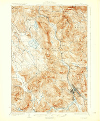
1930 Map of Rumford
USGS Topo · Published 1930About this map
The Androscoggin River and the Swift River dominate this mountain landscape, meeting at the industrial hub of Rumford. In the late 1920s, the Maine Central R.R. follows the river valleys, connecting settlements like Ridlonville, Virginia, and Mexico. The topographic data reveals a network of rural education, with several localized schoolhouses such as Horseshoe Sch and North Rumford Sch serving the farming and timber communities outside the main towns.
Find a feature on this map
83 named features on this map. Tap any name to fly to it.
Don’t see what you’re looking for? This feature index may not catch every label — zoom into the map to look around manually.
Map Details
Editions of this 1930 Rumford Map
5 editions found
Other maps of this area

1911 · Bryant Pond
USGS Topo · 1:62,500

1911 · Buckfield
USGS Topo · 1:62,500

1913 · Buckfield
USGS Topo · 1:62,500

1914 · Bethel
USGS Topo · 1:62,500

1914 · Bryant Pond
USGS Topo · 1:62,500

1926 · Dixfield
USGS Topo · 1:62,500

1927 · Rumford
USGS Topo · 1:48,000

1929 · Phillips
USGS Topo · 1:48,000

1929 · Dixfield
USGS Topo · 1:62,500

1930 · Rumford
USGS Topo · 1:62,500