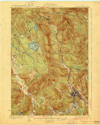
1930 Map of Rumford
USGS Topo · Published 1930About this map
The Androscoggin River serves as the industrial and logistical spine of this Oxford County landscape, where the Maine Central Railroad follows the river's curve into the manufacturing hubs of Rumford and Mexico. This 1930 edition shows a region defined by the transition from riverfront paper and pulp operations to the remote agricultural and mining interests of the surrounding hills. In the western reaches, the Newry Mine and Stockbridge Cem reflect the area’s early resource extraction and family settlement patterns.
Find a feature on this map
86 named features on this map. Tap any name to fly to it.
Don’t see what you’re looking for? This feature index may not catch every label — zoom into the map to look around manually.
Map Details
Editions of this 1930 Rumford Map
5 editions found
Other maps of this area

1911 · Bryant Pond
USGS Topo · 1:62,500

1911 · Buckfield
USGS Topo · 1:62,500

1913 · Buckfield
USGS Topo · 1:62,500

1914 · Bethel
USGS Topo · 1:62,500

1914 · Bryant Pond
USGS Topo · 1:62,500

1926 · Dixfield
USGS Topo · 1:62,500

1927 · Rumford
USGS Topo · 1:48,000

1929 · Phillips
USGS Topo · 1:48,000

1929 · Dixfield
USGS Topo · 1:62,500

1930 · Rumford
USGS Topo · 1:62,500