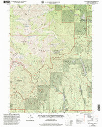
1998 Map of Rush Creek Lakes
USGS Topo · Published 2003About this map
Trinity Alps Wilderness and the Shasta-Trinity National Forests dominate this landscape in the late 1990s, revealing a region defined by high-altitude peaks and intricate drainage networks. High points like Monument Peak and Bally overlook a complex watershed where Rush Creek and Buckeye Creek feed into the South Fork Trinity River. The map captures the meeting of recreational and industrial history, from the Trinity Alps Resort in the northeast to the remote Tip Top Mine and Arbuckle Mine.
Find a feature on this map
55 named features on this map. Tap any name to fly to it.
Don’t see what you’re looking for? This feature index may not catch every label — zoom into the map to look around manually.
Map Details
Editions of this 1998 Rush Creek Lakes Map
This is the sole edition of this map. No revisions or reprints were ever made.
Other maps of this area

1890 · Red Bluff
USGS Topo · 1:250,000

1894 · Red Bluff
USGS Topo · 1:250,000

1909 · Big Bar
USGS Topo · 1:96,000

1913 · Weaverville
USGS Topo · 1:125,000

1915 · Big Bar and Vicinity
USGS Topo · 1:250,000

1950 · Minersville
USGS Topo · 1:62,500

1950 · Weaverville
USGS Topo · 1:62,500

1951 · Hayfork
USGS Topo · 1:62,500

1951 · Helena
USGS Topo · 1:62,500

1952 · Weaverville
USGS Topo · 1:62,500