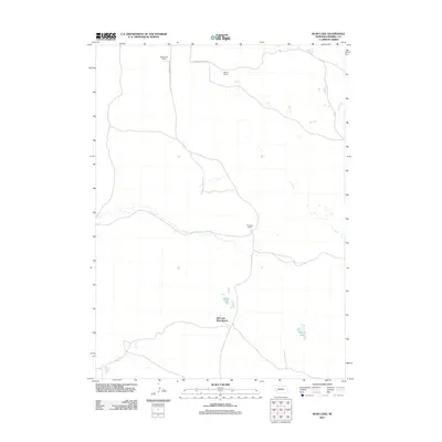
2011 Map of Rush Lake
USGS Topo · Published 2011About this map
Nebraska Boys Ranch sits at the heart of this Morrill County landscape, where the Sandhills terrain is defined by isolated ranching operations and seasonal water bodies. The presence of named holdings like Applegarth Ranch, Bignell Ranch, and Thompson Ranch reflects the enduring agricultural heritage of this high plains region. Navigation through this sparsely populated territory is anchored by Broadwater Rd and Alliance Refuge Rd, which connect the remote homesteads to the wider county network. Water features such as Rush Lake and Carver Lake are critical landmarks in this semi-arid environment, serving as vital resources for both the ranches and local wildlife. This 2011 survey captures the spatial organization of these large private holdings, illustrating how topographic relief and water access continue to dictate the placement of structures and routes in western Nebraska.
Find a feature on this map
8 named features on this map. Tap any name to fly to it.
Don’t see what you’re looking for? This feature index may not catch every label — zoom into the map to look around manually.
Map Details
Editions of this 2011 Rush Lake Map
This is the sole edition of this map. No revisions or reprints were ever made.
Other maps of this area

1896 · Browns Creek
USGS Topo · 1:125,000

1899 · Browns Creek
USGS Topo · 1:125,000

1947 · Alliance
USGS Topo · 1:24,000

1947 · Bronco Lake
USGS Topo · 1:24,000

1948 · Alliance
USGS Topo · 1:24,000

1948 · Antioch
USGS Topo · 1:62,500

1949 · Lynn
USGS Topo · 1:62,500
1949 · Bronco Lake
USGS Topo · 1:24,000

1949 · Antioch
USGS Topo · 1:62,500

1950 · Storm Lake
USGS Topo · 1:62,500