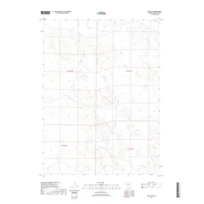
2017 Map of Rush Lake
USGS Topo · Published 2017About this map
The alkaline-marsh landscape of the Nebraska Sandhills is defined here by ephemeral water bodies and the sprawling townships of Morrill County. This high-plains terrain is sparsely marked by human infrastructure, with the most prominent landmarks being Rush Lake and Carver Lake, which sit at the center of complex wetland networks. The map documents a fragile hydrological system where small ponds and depressions are scattered across the shifting dunes, providing a look at the natural drainage patterns that dominate this section of the state. Transportation is limited to a grid of rural routes including Rd 129 and Rd 125, which navigate the elevation changes between the wetlands and the surrounding ridges. This survey illustrates the isolation of the region, where the Public Land Survey System grids such as t23n r47w and t22n r48w provide the primary framework for land management in a territory largely void of dense settlement.
Find a feature on this map
10 named features on this map. Tap any name to fly to it.
Don’t see what you’re looking for? This feature index may not catch every label — zoom into the map to look around manually.
Map Details
Editions of this 2017 Rush Lake Map
This is the sole edition of this map. No revisions or reprints were ever made.
Other maps of this area
1896 · Browns Creek
USGS Topo · 1:125,000
1899 · Browns Creek
USGS Topo · 1:125,000
1947 · Alliance
USGS Topo · 1:24,000
1947 · Bronco Lake
USGS Topo · 1:24,000
1948 · Alliance
USGS Topo · 1:24,000
1948 · Antioch
USGS Topo · 1:62,500
1949 · Lynn
USGS Topo · 1:62,500
1949 · Bronco Lake
USGS Topo · 1:24,000
1949 · Antioch
USGS Topo · 1:62,500
1950 · Storm Lake
USGS Topo · 1:62,500