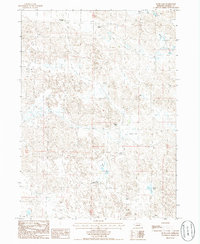
1986 Map of Rush Lake
USGS Topo · Published 1986About this map
Sandhills cattle ranching and scattered alkaline lakes define this Morrill County landscape as it was documented in the mid-1980s. The terrain is characterized by a high density of small depressions and seasonal water bodies, with larger named features like Smith Lake and Rush Lake serving as focal points for the surrounding ranchlands. Large-scale agricultural operations are the primary human footprint, marked by family and institutional holdings such as the Applegarth Ranch, Bignell Ranch, and the Nebraska Boys Ranch. The network of unimproved roads and trails reflects the necessity of navigating this undulating terrain to reach isolated homesteads like the Thompson Ranch. This survey provides a clear view of the rural settlement patterns and natural drainage in a region where water management and grazing land were the primary drivers of the local economy.
Find a feature on this map
11 named features on this map. Tap any name to fly to it.
Don’t see what you’re looking for? This feature index may not catch every label — zoom into the map to look around manually.
Map Details
Editions of this 1986 Rush Lake Map
This is the sole edition of this map. No revisions or reprints were ever made.
Other maps of this area

1896 · Browns Creek
USGS Topo · 1:125,000

1899 · Browns Creek
USGS Topo · 1:125,000

1947 · Alliance
USGS Topo · 1:24,000

1947 · Bronco Lake
USGS Topo · 1:24,000

1948 · Alliance
USGS Topo · 1:24,000

1948 · Antioch
USGS Topo · 1:62,500

1949 · Lynn
USGS Topo · 1:62,500
1949 · Bronco Lake
USGS Topo · 1:24,000

1949 · Antioch
USGS Topo · 1:62,500

1950 · Storm Lake
USGS Topo · 1:62,500