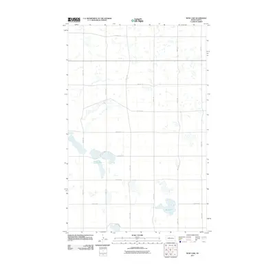
2011 Map of Rush Lake
USGS Topo · Published 2011About this map
Glacial depressions and prairie potholes dominate this corner of Ward County, where the landscape is defined by the shifting shorelines of Rush Lake and the connected waters of Nelson and Carlson Lakes. The topography here is relatively level, organized by a strict cardinal grid of rural roads such as 233rd Ave SE and 128th St SW. These section-line roads trace the agricultural heritage of the region, providing access to the scattered wetlands that dot the northern Great Plains. The water bodies represented on this map vary in size and permanence, reflecting the local hydrology of the Souris River basin. Unlike more developed regions, this area remains characterized by its open spaces and the intersection of rural thoroughfares like 100th St SW and 303rd Ave SW, which facilitate the transport of goods across this sparsely populated prairie landscape.
Find a feature on this map
16 named features on this map. Tap any name to fly to it.
Don’t see what you’re looking for? This feature index may not catch every label — zoom into the map to look around manually.
Map Details
Editions of this 2011 Rush Lake Map
This is the sole edition of this map. No revisions or reprints were ever made.
Other maps of this area

1928 · Minot
USGS Topo · 1:62,500

1954 · Minot
USGS Topo · 1:250,000

1954 · McClusky
USGS Topo · 1:250,000

1956 · Douglas West
USGS Topo · 1:24,000

1958 · McClusky
USGS Topo · 1:250,000

1958 · Minot
USGS Topo · 1:250,000

1980 · Minot
USGS Topo · 1:100,000

1980 · Lake Vernon
USGS Topo · 1:24,000
1980 · South Prairie
USGS Topo · 1:24,000
1980 · Douglas East
USGS Topo · 1:24,000