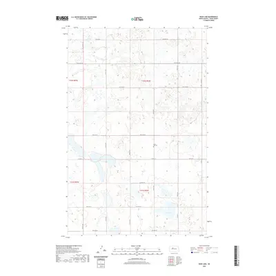
2020 Map of Rush Lake
USGS Topo · Published 2020About this map
Rush Lake and its surrounding prairie wetlands dominate this central North Dakota landscape, revealing the intricate water patterns of Ward County as they appeared in 2020. The area is characterized by a sparse grid of section-line roads, such as 317th Ave SW and 345th Ave SW, which navigate around numerous unnamed seasonal ponds and potholes typical of the region's glacial topography. Co Hwy 22 and Co Hwy 15 serve as the primary conduits through this rural terrain. A single cultural landmark, the Spring Lake Cem, provides a specific point of interest for genealogists and local historians, sitting quietly amid the townships of t152n r84w and t151n r84w. The map preserves the exact alignment of these rural routes and water bodies before further modern agricultural or climatic changes might alter the landscape.
Find a feature on this map
15 named features on this map. Tap any name to fly to it.
Don’t see what you’re looking for? This feature index may not catch every label — zoom into the map to look around manually.
Map Details
Editions of this 2020 Rush Lake Map
This is the sole edition of this map. No revisions or reprints were ever made.
Other maps of this area

1928 · Minot
USGS Topo · 1:62,500

1954 · Minot
USGS Topo · 1:250,000

1954 · McClusky
USGS Topo · 1:250,000

1956 · Douglas West
USGS Topo · 1:24,000

1958 · McClusky
USGS Topo · 1:250,000

1958 · Minot
USGS Topo · 1:250,000

1980 · Minot
USGS Topo · 1:100,000

1980 · Lake Vernon
USGS Topo · 1:24,000
1980 · South Prairie
USGS Topo · 1:24,000
1980 · Douglas East
USGS Topo · 1:24,000