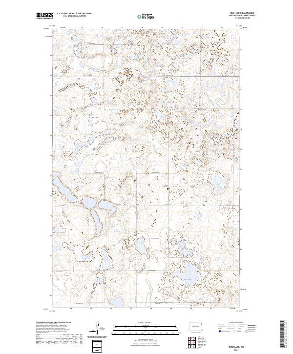
2024 Map of Rush Lake
USGS Topo · Published 2024About this map
Rush Lake and the surrounding prairie potholes define this section of Ward County, North Dakota, where the landscape is managed for wildlife and local agriculture. The Ward County Waterfowl Production Area occupies several non-contiguous blocks of land, preserving the marshy habitats critical to migratory birds. Human presence is marked by a precise grid of rural roads, including 100th St SW and 289th Ave SW, which facilitate movement between scattered farmsteads and fields. Centrally located on the sheet is the Spring Lake Cem, a small burial ground that serves as a quiet record of the families who settled this area of the northern plains. This survey represents the modern state of the land where glacial activity once carved out thousands of small depressions that now form the basis of the regional water and ecology systems.
Find a feature on this map
21 named features on this map. Tap any name to fly to it.
Don’t see what you’re looking for? This feature index may not catch every label — zoom into the map to look around manually.
Map Details
Editions of this 2024 Rush Lake Map
This is the sole edition of this map. No revisions or reprints were ever made.
Other maps of this area

1928 · Minot
USGS Topo · 1:62,500

1954 · Minot
USGS Topo · 1:250,000

1954 · McClusky
USGS Topo · 1:250,000

1956 · Douglas West
USGS Topo · 1:24,000

1958 · McClusky
USGS Topo · 1:250,000

1958 · Minot
USGS Topo · 1:250,000

1980 · Minot
USGS Topo · 1:100,000

1980 · Lake Vernon
USGS Topo · 1:24,000
1980 · South Prairie
USGS Topo · 1:24,000
1980 · Douglas East
USGS Topo · 1:24,000