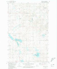
1980 Map of Rush Lake
USGS Topo · Published 1981About this map
Spring Lake Ch stands as a focal point in this 1980s landscape of Ward County, where the transition between agricultural land and protected wetlands is clearly defined. The terrain is characterized by numerous glacial depressions, most notably Rush Lake, which is surrounded by the National Waterfowl Production Area. This conservation designation reflects the region's importance to the Central Flyway, with large tracts of land dedicated to habitat preservation. Further west, Nelson Lake provides a hub for local recreation, featuring a designated Public Access point and Picnic Area. The land use pattern here is a mix of conservation and extraction, as evidenced by several Gravel Pits scattered across the townships of Rice Lake and Spring Lake. Small-scale infrastructure like the local church and the system of section-line roads illustrates the quiet, rural character of the area in the late twentieth century.
Find a feature on this map
13 named features on this map. Tap any name to fly to it.
Don’t see what you’re looking for? This feature index may not catch every label — zoom into the map to look around manually.
Map Details
Editions of this 1980 Rush Lake Map
This is the sole edition of this map. No revisions or reprints were ever made.
Other maps of this area

1928 · Minot
USGS Topo · 1:62,500

1954 · Minot
USGS Topo · 1:250,000

1954 · McClusky
USGS Topo · 1:250,000

1956 · Douglas West
USGS Topo · 1:24,000

1958 · McClusky
USGS Topo · 1:250,000

1958 · Minot
USGS Topo · 1:250,000

1980 · Minot
USGS Topo · 1:100,000

1980 · Lake Vernon
USGS Topo · 1:24,000
1980 · South Prairie
USGS Topo · 1:24,000
1980 · Douglas East
USGS Topo · 1:24,000