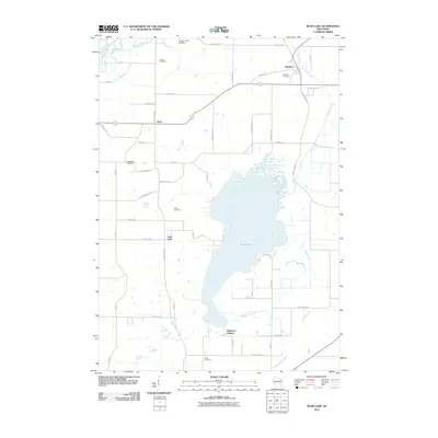
2010 Map of Rush Lake
USGS Topo · Published 2010About this map
Rush Lake dominates this central Wisconsin landscape, providing a focus for the surrounding rural communities of Waukau, Koro, and Wilmoore Heights. The 2010 geography reveals a highly organized township structure, where an extensive grid of country roads like Koro Rd, Island Rd, and County Hwy-V connects family farms and local landmarks. Genealogists will find significant value in the distribution of several burial grounds across the quadrangle, including Eureka Cemetery in the north and Loper Cemetery in the south, suggesting the locations of early parish centers or family plots. A distinctive modern feature is the Happy Jacks Air Strip near the northern boundary, while the hydrography is defined by the marshy outlets of Waukau Creek and Henderson Creek, which drain the lake's shallow basin. The map illustrates a stable agricultural region where modern infrastructure overlays a well-preserved nineteenth-century settlement pattern.
Find a feature on this map
43 named features on this map. Tap any name to fly to it.
Don’t see what you’re looking for? This feature index may not catch every label — zoom into the map to look around manually.
Map Details
Editions of this 2010 Rush Lake Map
This is the sole edition of this map. No revisions or reprints were ever made.
Other maps of this area

1916 · Ripon
USGS Topo · 1:48,000

1918 · Ripon
USGS Topo · 1:62,500

1955 · Green Bay
USGS Topo · 1:250,000

1956 · Ripon
USGS Topo · 1:62,500

1956 · Rosendale
USGS Topo · 1:62,500

1957 · Madison
USGS Topo · 1:250,000

1960 · Madison
USGS Topo · 1:250,000

1961 · Poy Sippi
USGS Topo · 1:62,500

1961 · Oshkosh
USGS Topo · 1:62,500
1961 · Auroraville
USGS Topo · 1:24,000