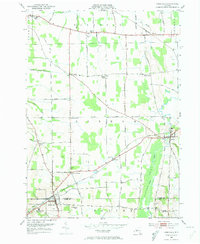
1952 Map of Rushville
USGS Topo · Published 1974About this map
The village of Rushville sits at the intersection of Ontario and Yates Counties, serving as a hub for this agricultural region in the early 1950s. The landscape is defined by the steady flow of Flint Creek and the West River, which carve through the terrain between high points like Harkness Hill and Lazarus Hill. A network of rural settlements, including Gorham, Baldwin Corners, and Aloquin, are connected by an extensive grid of country roads and two major rail lines: the Lehigh Valley and the Pennsylvania railroads.
Find a feature on this map
68 named features on this map. Tap any name to fly to it.
Don’t see what you’re looking for? This feature index may not catch every label — zoom into the map to look around manually.
Map Details
Editions of this 1952 Rushville Map
Other maps of this area

1900 · Naples
USGS Topo · 1:62,500

1900 · Canandaigua
USGS Topo · 1:62,500

1902 · Phelps
USGS Topo · 1:62,500

1903 · Naples
USGS Topo · 1:62,500

1903 · Canandaigua
USGS Topo · 1:62,500

1903 · Penn Yan
USGS Topo · 1:62,500

1913 · Naples
USGS Topo · 1:62,500

1942 · Penn Yan
USGS Topo · 1:31,680

1942 · Middlesex
USGS Topo · 1:31,680

1942 · Canandaigua
USGS Topo · 1:31,680