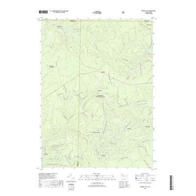
2019 Map of Russell City
USGS Topo · Published 2019About this map
Allegheny National Forest dominates this northern Pennsylvania landscape, where the intersections of four counties—Warren, Forest, Elk, and McKean—meet in a dense network of timberlands and drainage basins. Small settlements and former rail stops like Brookston, Sheffield Junction, and Chaffee are scattered throughout the forest, connected by an extensive modern recreational infrastructure. The map details a labyrinth of specialized trails, including the Marienville ATV system and several loops of the Timberline ATV A Loop, illustrating how these once-industrial corridors have been repurposed for motorized recreation. Waterways such as the S Br Tionesta Cr and East Branch Spring Creek cut through the terrain, while curious local place names like Pigs Ear, Corduroy, and Windy City provide a window into the region's colloquial history and settlement patterns.
Find a feature on this map
72 named features on this map. Tap any name to fly to it.
Don’t see what you’re looking for? This feature index may not catch every label — zoom into the map to look around manually.
Map Details
Editions of this 2019 Russell City Map
This is the sole edition of this map. No revisions or reprints were ever made.
Other maps of this area

1918 · Loleta
USGS Topo · 1:62,500

1934 · Kane
USGS Topo · 1:48,000

1935 · Sheffield
USGS Topo · 1:48,000

1936 · Marienville
USGS Topo · 1:48,000

1939 · Kane
USGS Topo · 1:62,500

1940 · Hallton
USGS Topo · 1:48,000

1941 · Sheffield
USGS Topo · 1:62,500

1941 · Marienville
USGS Topo · 1:62,500

1943 · Hallton
USGS Topo · 1:62,500

1957 · Warren
USGS Topo · 1:250,000
Featured Places
- Sheffield Township, PA
- Sackett, Highland Township
- Dunring, Jenks Township
- Russell City, Highland Township
- Jenks Township, PA