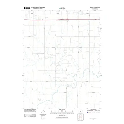
2012 Map of Russell SW
USGS Topo · Published 2012About this map
The Smoky Hill River meanders across the southern portion of this Russell County landscape, defining the local drainage patterns alongside Big Cr and Fossil Cr. This 2012 survey illustrates a section of the Kansas plains organized by a rigid grid of section-line roads, such as Lincoln Rd and Grant Rd, which facilitate agricultural movement between the smaller waterways. The influence of modern transit is visible in the north, where I 70 Rd cuts through the territory near Homer Rd. This map captures the rural character of the region, where the natural curves of Walker Cr contrast sharply with the straight-line development of local infrastructure like 178th St and 181st St.
Find a feature on this map
22 named features on this map. Tap any name to fly to it.
Don’t see what you’re looking for? This feature index may not catch every label — zoom into the map to look around manually.
Map Details
Editions of this 2012 Russell SW Map
This is the sole edition of this map. No revisions or reprints were ever made.
Other maps of this area

1896 · Russell
USGS Topo · 1:125,000

1896 · Hays
USGS Topo · 1:125,000

1955 · Great Bend
USGS Topo · 1:250,000

1957 · Great Bend
USGS Topo · 1:250,000

1958 · Great Bend
USGS Topo · 1:250,000
1961 · Walker
USGS Topo · 1:24,000

1961 · Russell SW
USGS Topo · 1:24,000

1961 · Homer
USGS Topo · 1:24,000

1967 · Russell NW
USGS Topo · 1:24,000

1967 · Russell
USGS Topo · 1:24,000