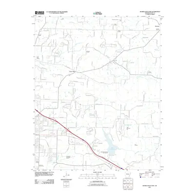
2011 Map of Russellville East
USGS Topo · Published 2011About this map
Galla Creek Lake and its surrounding watershed dominate the southeastern corner of this Pope County landscape, illustrating the engineered water management systems of the early 21st century. The map details a complex network of rural and suburban development expanding eastward from the city center toward settlements like Center Valley and Moreland. Genealogists will find a high density of burial sites throughout the quadrangle, including the Old Baptist Cemetery, Saint Paul Cemetery, and the expansive Rest Haven Memorial Park. These sites, often situated near secondary watercourses like Linker Creek or Bakers Creek, reflect the long-standing community foundations in this part of Arkansas. The infrastructure supporting the region is clearly defined by the Russellville Municipal Airport and the Moreland Gas Field, marking the intersection of local aviation and resource extraction. Significant water features like Lake Yarbrough and the Galla Watershed Site One Lake Dam further define the local topography near Gravel Hill.
Find a feature on this map
168 named features on this map. Tap any name to fly to it.
Don’t see what you’re looking for? This feature index may not catch every label — zoom into the map to look around manually.
Map Details
Editions of this 2011 Russellville East Map
This is the sole edition of this map. No revisions or reprints were ever made.
Other maps of this area

1888 · Dardanelle #4
USGS Topo · 1:62,500

1888 · Dardanelle #1
USGS Topo · 1:62,500

1889 · Morrilton No. 3
USGS Topo · 1:62,500

1890 · Dardanelle
USGS Topo · 1:125,000

1892 · Morrillton
USGS Topo · 1:125,000

1894 · Morrillton
USGS Topo · 1:125,000

1956 · Russellville
USGS Topo · 1:250,000

1961 · Atkins
USGS Topo · 1:24,000
1961 · Dover
USGS Topo · 1:24,000
1962 · Hector
USGS Topo · 1:24,000